[ Content | View menu ]

Dr. Cook Artifacts 9: The Freedom of the City of New York, October 15, 1909

October 15, 2024

Exactly 115 years ago today, as mentioned in the last post, Frederick Cook was the first American to be offered the Freedom of the City of New York. Only the Prince of Prussia and Charles Dickens before him had been accorded this honor, and it was protested by the pro-Peary interests. General Thomas Hubbard wrote a personal letter to the President of the Board of Aldermen asking that the ceremony be postponed, as did the Explorers Club, in light of its ongoing investigation into Dr. Cook’s claim to have climbed Mt. McKinley in 1906 (see the posts for October, November 2017 and January 2018 below).

cook with escort 2

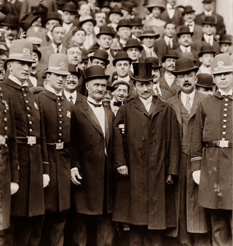
Cook arrived at City Hall in top hat and tails, fifteen minutes late and flanked by an honor guard of New York’s Finest, assigned to get him through the crowd of curious onlookers gathered outside. He appeared in the firm grip of Capt. B.S. Osbon, the Arctic Club’s Secretary, on hand for the presentation of the Arctic Club’s gold medal. Before going in, Cook asked for a meeting with the Alderman President Patrick F. McGowan.

Two-thirds of the Aldermen were assembled in the Aldermanic Chamber to receive him along with a crowd of onlookers including Cook’s two brothers and his sister, Captain Osbon, Henry Biederbeck, survivor of the Greely expedition, and Dr. Stebbins, who was to present the medal. Also present were two members of Peary’s 1909 expedition, Donald MacMillan and George Borup.

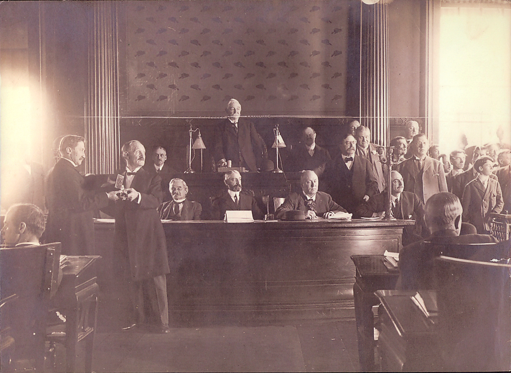
As he entered the room, two full minutes of applause greeted him. After the presentation of the gold medal, Mr. McGowan spoke. “I deem it only fair to Dr. Cook to say that he wanted this action of the Board of Alderman postponed. The Chair has absolute confidence in Dr. Cook and for that reason a postponement has been refused, although Dr. Cook, with his characteristic manliness, requested that we wait until all proofs are in.” The ceremony presenting the Freedom of the City then commenced.

Freedom of City

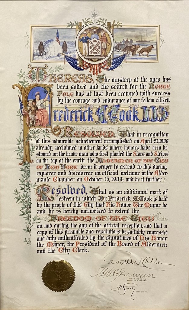
Dr. Cook was then handed the mahogany box that contained a 15 by 23-inch engrossed sheet of vellum representing the honor being bestowed by President McGowan. On the illuminated scroll, designed by Malcolm and Hayes of New York, were representations of his igloo at the North Pole and a team of dogs pulling a sledge, with the schooner John R. Bradley riding at anchor in the distance. At the top rested the Seal of the City of New York upon two draped American flags. The first initial of Cook’s name held the figure of Columbia seated on a throne, holding aloft a laurel wreath about to be placed on the explorer, clad in furs and holding an American flag. The inscription o the scroll began, “Whereas the mystery of the ages has been solved. . .” It was signed by the mayor and Alderman McGowan.

Cook Scroll adjusted

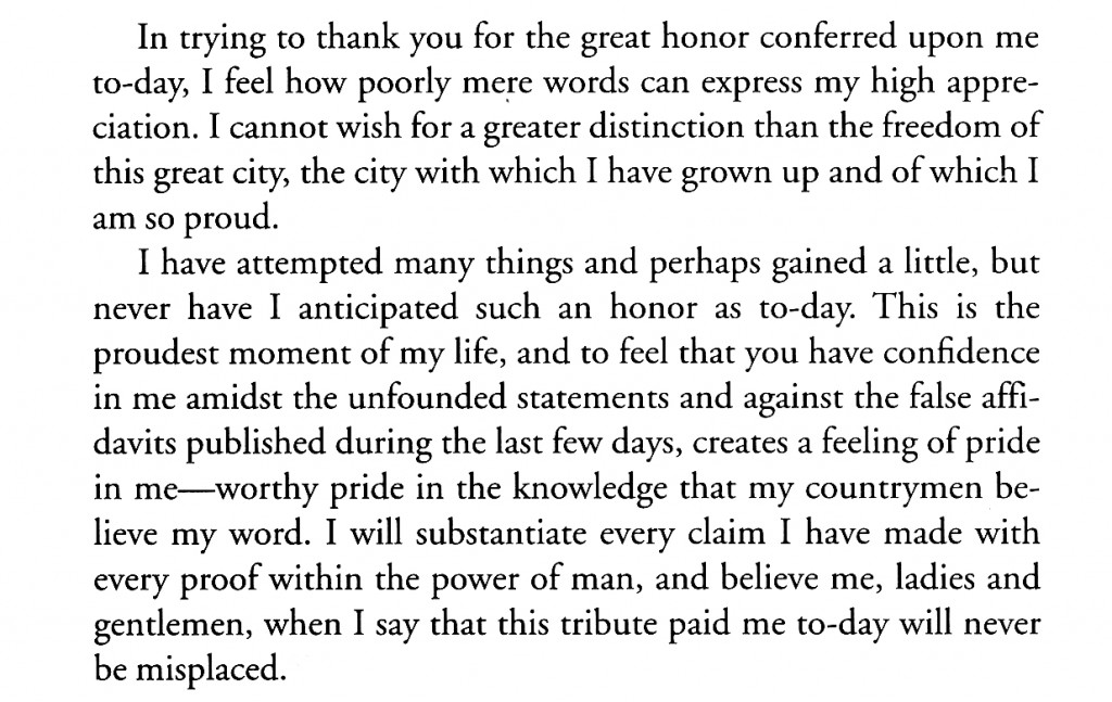
As the alderman handed the scroll to Cook, the flash powder in one of the camera trays set afire a huge cloth bag intended to catch the smoke of the flashlight. It blazed up, scorching the portrait of George Washington that hung on the east wall. After the commotion this caused quieted down, Cook made a brief speech:

cook speech

The vellum scroll is now in the possession of the Sullivan County Historical Society Museum in Hurleyville, New York.

The photograph of the scroll is courtesy of Darrell Hartman.
The other illustrations are from the author’s collection.

Uncategorized

Dr. Cook Artifacts 8: Souvenirs of the Arctic Club Dinner, September 23, 1909.

September 3, 2024

In the wake of his triumphal return to New York, and despite Peary’s charges that Cook’s prior claim to the North Pole was a “gold brick,” the Arctic Club of America decided on a gala dinner in his honor to be held on September 23 at the Waldorf-Astoria. A grand assembly of 1,185 guests in formal dress who had paid anywhere from $5-$30 for the privilege, thronged the vast banquet hall of the hotel, festooned with intertwined flags of the United States and Denmark. Cook, escorted by the club’s sitting president, retired Admiral Winfield Scott Schley, shook hands with more than 600 of them at the preliminary reception in the Astor Gallery before sitting down to dinner.
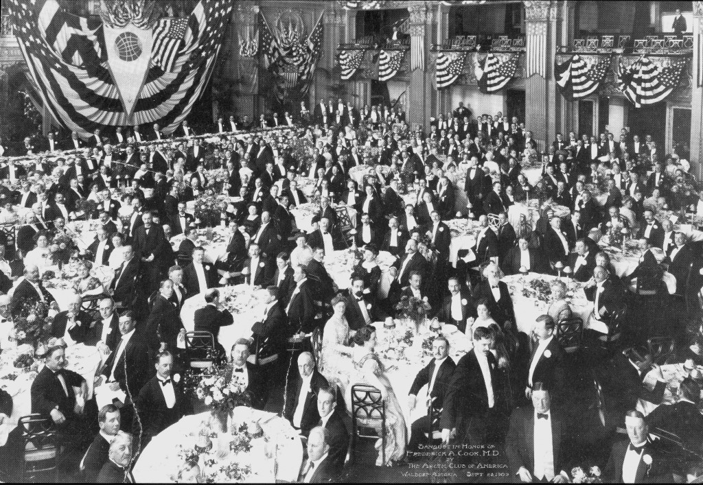
Arctic Club Dinner 2Over the head table hung the huge white burgee of the Bradley Arctic Expedition. In the official photograph of the event Dr. Cook is seated just to the left of the point of the burgee, with Admiral Schley to his left and John R. Bradley, the millionaire gambler who financed the expedition, to Cook’s right.

During the meal there were speeches and numberless toasts to the explorer’s health, including one from Count Harald Moltke, representing Denmark, where Cook had been received as a hero upon his return from the Arctic earlier in the month. It was 10 o’clock before Cook was introduced to speak by Admiral Schley to thunderous applause.

He thanked all those present, many who had been to the Arctic themselves, for “one of the highest honors I ever hope to receive,” and then, when he asked, referring to the growing controversy between him and Peary, “Now, gentlemen, I appeal to you as explorers and men. Am I bound to appeal to anybody, to any man, to any body of men, for a license to look for the pole?” he received a spontaneous and rousing “NO!” from the assembled dinners. When he paid homage to his benefactor, John R. Bradley was compelled to stand on his chair to acknowledge the ovation.

After his address, Cook adjourned to the Grand Ballroom, where he shook hands with more than 2,000 until midnight. At his departure he told Arctic Club officials, “My hand is a little sore but otherwise I never felt better in my life. It has been a great night and I hardly know how to express my appreciation for the cordial reception which has been given me by my fellow explorers. It is needless to say that the memory of this occasion will ever be cherished.”

Cherished, too, was the beautiful souvenir menu given each of the attendees. Here all of the pages are reproduced followed by a few comments on each of them.

The menu consists of a fold-over cover forming its front and back, with seven one-sided pages bound in between at the upper left corner by a pair of ribbons, one white and the other red, white and blue.
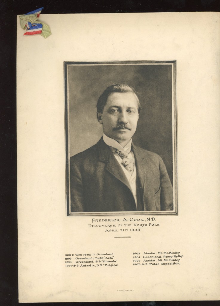
Menu 1 front

The front cover has a photogravure portrait of Cook taken in 1907. Below it is a list of the expeditions he participated in. The one listed as “1904” actually occurred in 1901, and so is out of order.  This mistake is not repeated in Cook’s biography on page 3, where it is reported correctly.
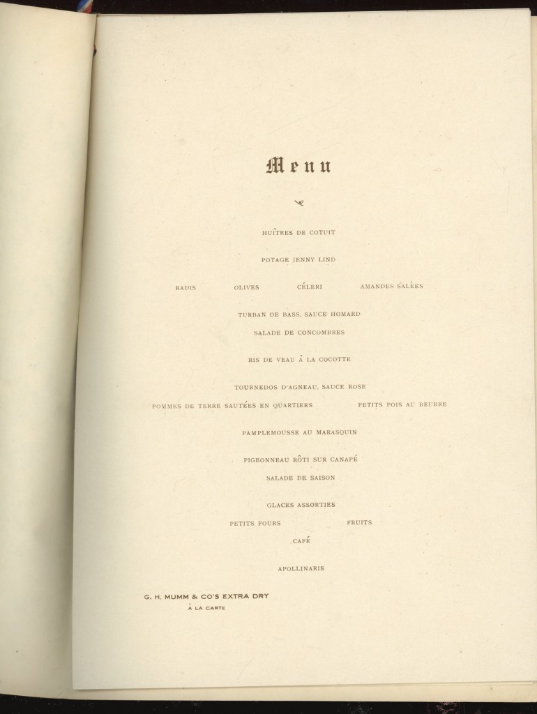
Menu 2 MenuThe first inner page presents the dinner menu, all in French. For those who don’t read French, the main course was roast squab.
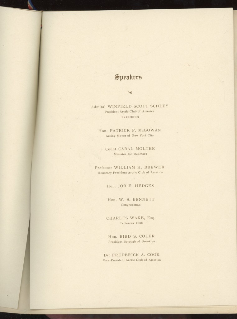
Menu 3 speakers

The second page lists the formal speakers. All are identified except for Job E. Hedges. He was an attorney and New York Republican political activist who would be the unsuccessful Republican nominee for Governor of New York in 1912. Dr. Cook was a Democrat.
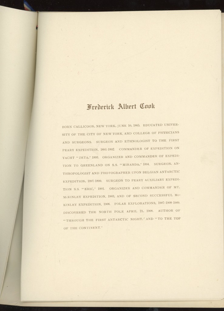
Menu 4 bio

The third page, containing Cook’s biography, also has an error. Cook was not born in Callicoon, New York, but in Hortonville, a hamlet a few miles north of that town.
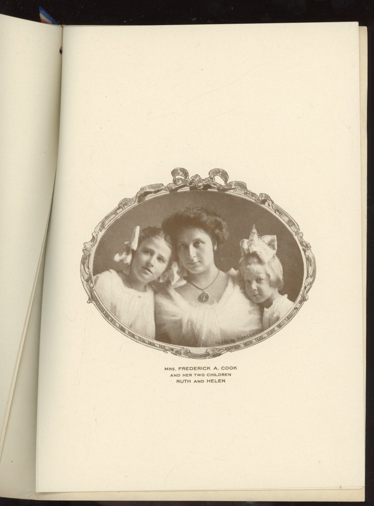
Menu 5 Marie

The fourth page portrait of Dr. Cook’s wife, Marie Fidell Hunt, shows her wearing on a chain around her neck one of the silver medals Cook received from the city of Brussels in appreciation of his service as surgeon to the Belgian Antarctic Expedition. At the time she married Cook in 1902, Marie was the widow of Dr. Willis Hunt of Camden, NJ. Ruth Hunt (left) was her daughter by that first marriage, born in 1898. Helen, who was Dr. Cook’s only surviving natural child, was born in 1905. She was named after Helen Bridgman, wife of Herbert L. Bridgman, longtime Secretary of the Peary Arctic Club. Perhaps that is why she styled herself Helene in adulthood. The white silk gown Marie Cook wore to the dinner is preserved at the Sullivan County Historical Society in Hurleyville, NY.
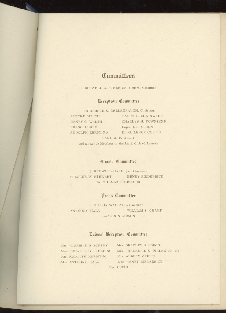
Menu 6 Committees

The fifth page shows the committees responsible for the event. The Arctic Club was formed in 1894 by the “survivors” of the disastrous Miranda expedition organized by Cook that year. The ship was lost but there were no casualties. Many of its later members were members of various arctic expeditions. The Arctic Club was absorbed by the Explorers Club in 1913. Cook was the second president of both clubs.
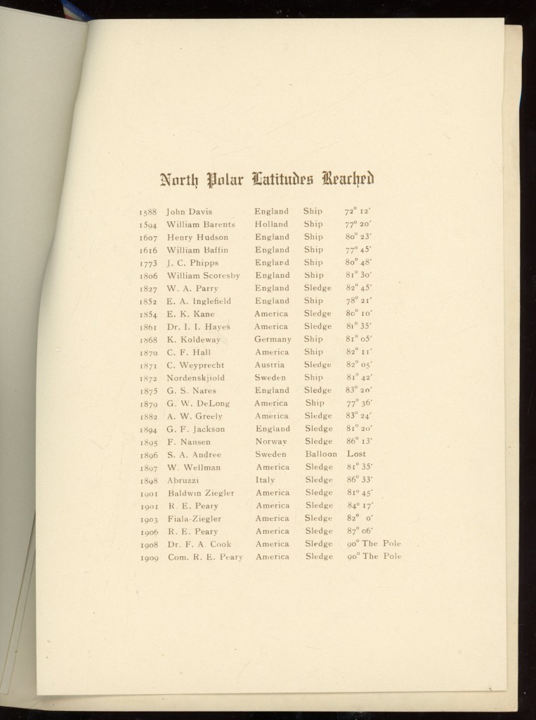
Menu 7 records

The sixth page shows a list of “farthest norths” reached by various explorers.
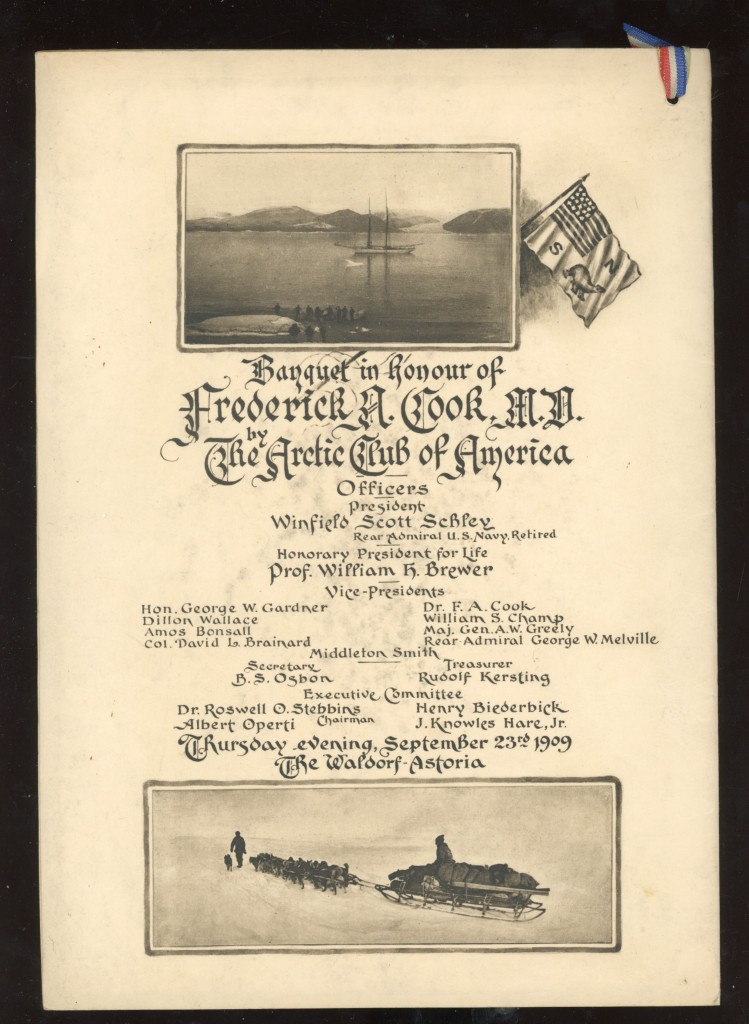
Menu back

The back cover shows the yacht John R. Bradley in Foulke Fjord, the harbor at Etah, Greenland, flanked by the Arctic Club’s flag. This was the ship that took Cook to the Arctic in 1907 for his attempt on the Pole the following Spring. This is followed by a list of the officers of the club. Professor Brewer was the first president and honorary President for Life thereafter. His papers are held at Yale University. Below the officers list is a photograph taken on the 1903 Fiala-Ziegler Expedition by Anthony Fiala on his failed attempt to reach the North Pole in 1904. The sled shown in it was built by Dr. Cook’s brother, Theodore.

The Arctic Club authorized the striking of a gold medal to be presented to Cook at the banquet.  For many years the whereabouts of this medal were not known. About 2005 it was disclosed to be in the collections of the Missouri Historical Society of St. Louis. It was donated to the society in 1914 by an unrecorded benefactor.

Here is its official description from the society’s website:
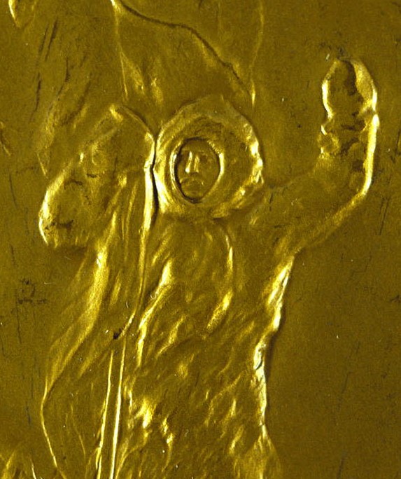
Arctic club medal 5

“Commemorative Polar Exploration Medal Presented to Dr. Frederick A. Cook
The Arctic Club of America honored Dr. Frederick A. Cook by presenting this medal to him at the Waldorf-Astoria in New York, September 23, 1909. Cook claimed to have discovered the North Pole just days before Admiral Robert E. Peary announced he had also reached the pole. When Cook failed to prove that he had beaten Peary, the Arctic Club of America revoked his membership.”
The item identifier is 1914-029-0001 and can be viewed at:
https://mohistory.org/collections/item/1914-029-0001

This description is not quite correct. The medal was was not ready in time for the Arctic Club dinner. On October 15 Cook was scheduled to receive the unprecedented honor for an American citizen of the Freedom of the City of New York at the Aldermans’ Chamber in City Hall. Before he received the illuminated vellum scroll signifying this honor, he was presented with the Arctic Club’s gold medal by Dr. Roswell Stebbins, a doctor of dentistry, as its representative. In handing it to Cook the medal dropped to the floor, rolled away and had to be chased down.

Cook’s membership in the Arctic Club was not “revoked” when he failed to prove his claim. The official reason given for dropping him from its rolls was for “non-payment of dues.”
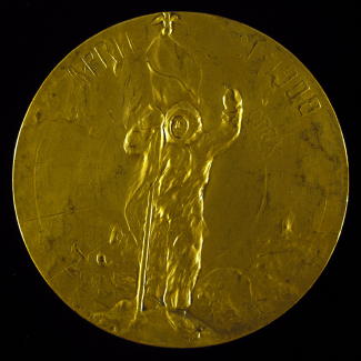
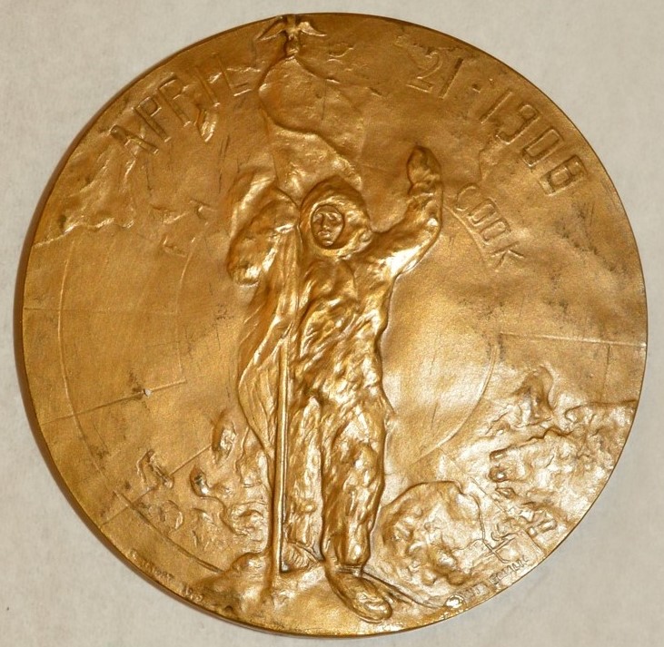
Arctic Club medalCook medal light background 1

The medal is 2 ½ inches in diameter. On the obverse Cook is shown, standing within the rings of latitude culminating in the North Pole, holding an American flag. Around the edges can be seen the lands bordering on the Arctic Ocean. It bears the inscriptions “April 21, 1908,” the date Cook claimed to have been at the Pole, and within that “F.A. Cook.” A copyright notice and the artist’s name are in incurse letters at the bottom edge.
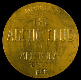
Arctic club medal 2Cook medal light backgrund 2

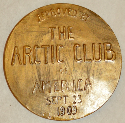
The reverse bears the inscription: “APPROVED BY / THE / ARCTIC CLUB / OF / AMERICA / SEPT. 23 / 1909.”, the date being engraved in incurse letters after the medal was struck.

The photo of the banquet is in the photographic collections of the Library of Congress.

The photos of the menu are all courtesy of Keith Thompson.

The photos of the medal are courtesy of the Missouri Historical Society of St. Louis, MO.
Uncategorized

Dr. Cook Artifacts 7: Dr. Cook at the Movies

August 23, 2024

Not long after returning to the United States from nearly a year of “exile,” in December 1910, Dr. Cook went to Chicago, then the center of the film industry.

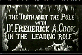
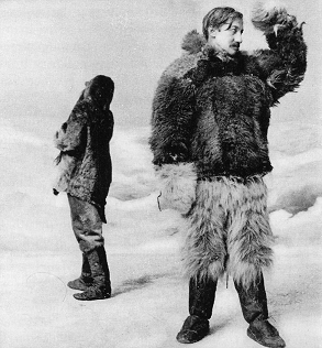
The result was the formation of the North Pole Picture Co. Its production, The Truth about the North Pole, in which Cook played himself, was designed to be shown along with planned personal appearances, reasserting that he was the first man to reach the North Pole.

tap1

clooking

A publicity photo for Cook’s film

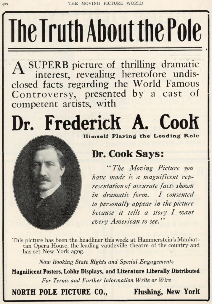
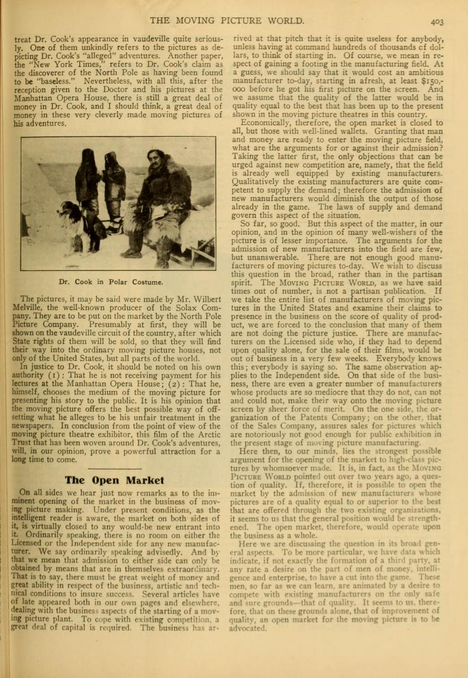
Once finished, Cook took out a full page ad in the trade publication, Moving Picture World to promote it.

Truth about the North Pole

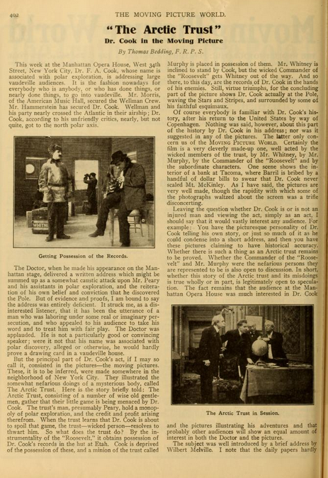
In this same issue the film was featured in a two page spread critiquing and publicizing the film.

Cook film 1.jpgCook film 2.jpg

When I was writing Cook & Peary in the early 1990s, Cook’s film had been completely forgotten. I learned of it first from an ad that appeared in the New York Herald advertising Cook’s appearance in which he first showed the film at Oscar Hammerstein’s Manhattan Opera House on February 12, 1911. Then while studying the Peary papers at the National Archives I came across a stenographic report of Cook’s performance and a blow by blow description of the film, commissioned by Herbert L. Bridgman, Secretary of the Peary Arctic Club and sent to Peary.

At that time, I then searched for a copy of the film, but failed to find it in any of the archival film libraries in the US. However, when I was  collaborating with BBC producer Tim Jordan on the BBC film Icemen in 1998, I was able to obtain a copy from a film footage dealer in California, whose catalog listed it, when the company’s search for it at the BBC’s request came up empty.

Since then, that copy has appeared on the internet, thus entering the public domain. Now, a slightly different, but superior copy has been located in the British Pathe film library, and is available on YouTube. You can view that copy at https://www.youtube.com/watch?v=cliewW_-4s8

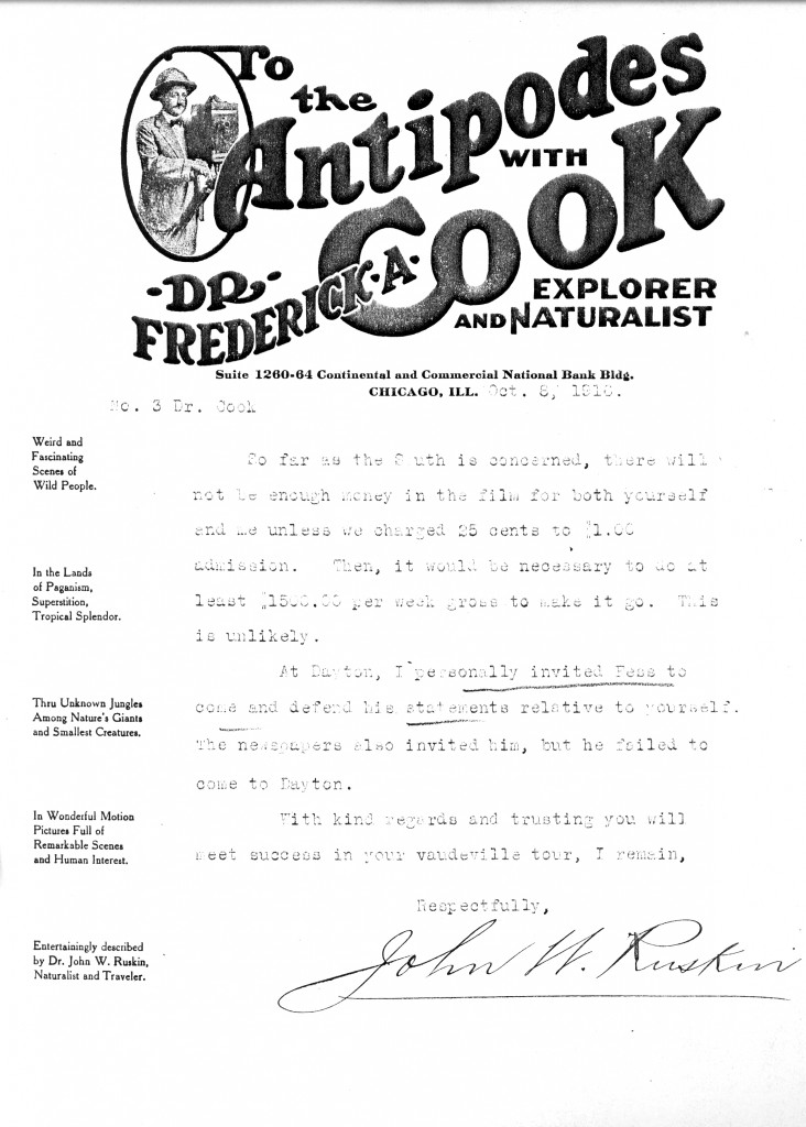
Although this film is now available to anyone, a copy of Cook’s other film, To the Antipodes, has yet to emerge. It was the only issue of Cook’s Orient Film Co.,  which he organized in Maine, and was put together from footage shot on Cook’s ‘round the world trip in 1915, which was originally aimed at an attempt to climb Mt. Everest. But because of wartime tensions, Cook, who was of German descent, was suspected of being a possible German agent, and the British refused to give Cook’s party passage through India to  enter Nepal, so he never got near the tallest mountain on earth. As a result, Cook was forced to fall back on a trip to Borneo, instead, where he filmed scenes of local color, including some among the Dyaks, the so-called “Wildmen of Borneo.”

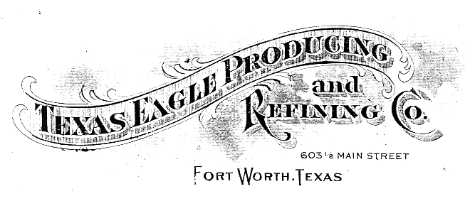
As can be seen from this letter to Cook from John W. Ruskin, a then popular lecturer on natural history subjects who appeared in the southern states to narrate the silent film, the movie was a financial flop and quickly faded as a commercial enterprise. But its promotion had all the elements of Cook’s penchant for advertising aplomb which landed him in Leavenworth Penitentiary ten years later, including the flamboyant letter head of his company’s stationary on which Ruskin broke the bad news to Dr. Cook.  Cook film

The ad and article appeared in Moving Picture World, Volume 8, no. 8, February 25, 1911.


The letter is in the Papers of Frederick A. Cook held in the manuscript division of the Library of Congress.

Uncategorized

The Cook-Peary Files: September 4, 1909: How Cook’s visit to Lerwick was reported in the local papers

July 4, 2024

This is the latest in a series of posts that publish for the first time significant documents related to the Polar Controversy.

Lerwick 1

Lerwick 2

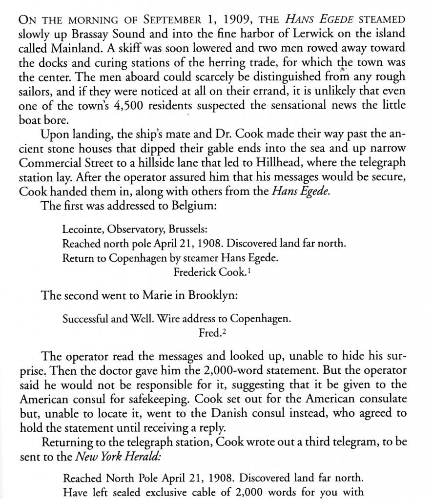
This is how I portrayed Dr. Cook’s stop at Lerwick in the Shetland Islands to announce his claim to have attained the North Pole on September 1, 1909 in my book, Cook & Peary, the Polar Controversy, resolved.

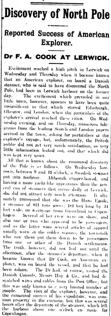
But it took a couple of days for rumors to spread through Lerwick about Cook’s claims. Here’s how the local papers in the Shetland Islands reported Cook’s visit; first the Shetland News for September 4, 1909:  Shetland1

Shetland2

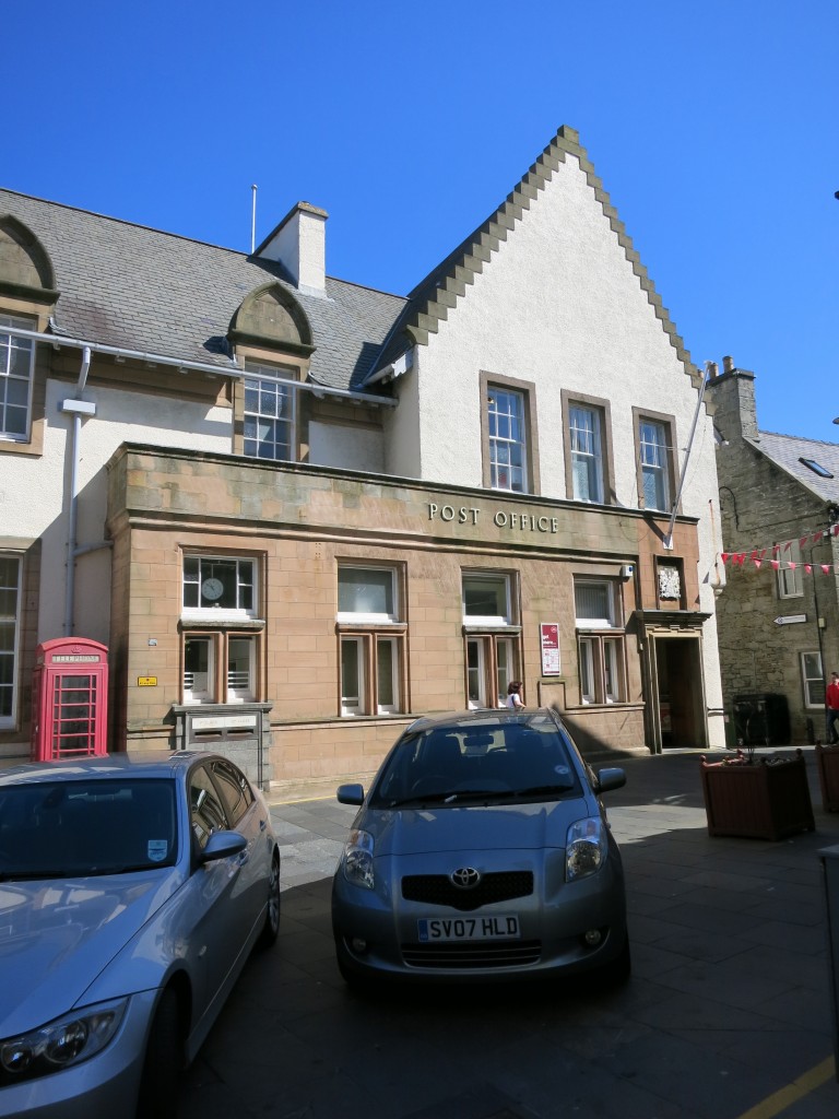
Post Office 3

Cook sent his cables  from the second floor of the Post Office on Commerce Street (photo by author)

Here’s the story from the Shetland Times for the same day, which was far more creative in its accounts of Cook’s journey:

shetland3

Shetland4

Finally, here is a letter that appeared on September 11 in that same newspaper, foreshadowing the great controversy to come:

Shetland5

Uncategorized

The Cook-Peary Files: October 17, 1909: ONE NIGHT ONLY! Matt Henson at the Hippodrome

June 17, 2024

This is the latest in a series of posts that publish for the first time significant documents related to the Polar Controversy.

Peary had given his longtime expedition member, Matthew A. Henson, the cold shoulder ever since their “arrival” at what Peary claimed was the North Pole. Henson reported Peary practically said nothing to him on the return journey and kept his distance once back aboard the Roosevelt. The silence continued upon the expedition’s return to the US in September 1909.

Once back in New York, Henson had an offer for a series of lectures from the well-known promoter William A. Brady. Brady had previously tried to land the lecture rights from Dr. Cook and then Peary without success. As a result of Brady’s offer, Henson wrote to Peary asking his permission to accept, and also for copies of some of Peary’s photographs and a lantern slide map of the Arctic to be shown at his appearances. Peary turned him down flat. This prompted Henson to tell Peary why he had decided to accept Brady’s offer anyway, saying, “I have been with you a good many years on these trips and have never derived any material benefits. I am not getting any younger, and it has come to an issue where I have to look out for myself.”

Brady broke Matt in with a lecture at Middletown, Connecticut. It was an awkward performance. Henson had a prepared text, but because he was functionally illiterate*, his hesitations in attempting to read it had to be constantly prompted from the wings. Finally, he just abandoned his script and simply talked about his 70 stereooptican slides as they were flashed on the screen, including one he claimed to be “the only photograph of the pole in existence,” after which he answered questions from the sparse audience. The receipts in Middletown amounted to less than $37 for two performances. But the appearance still made news.

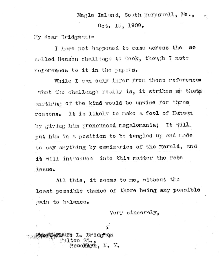
There were rumors that Henson had challenged Dr. Cook to a public debate. Peary wanted this to be avoided at all costs and seemed to fear what Henson might inadvertently say. He wrote to Herbert L. Bridgman, Secretary of the Peary Arctic Club:

Henson letter

(”I have not happened to come across the so called Henson challenge to Cook, though I note references to it in the papers

“While I can only infer from these references what the challenge really is, it strikes me that anything of the kind would be unwise for three reasons. It is likely to make a fool of Henson by giving him pronounce megalomania; it will put him in a position to be tangled up and made to say anything by emissaries of the [New York] Herald [which was backing Cook’s claim], and it will introduce into this matter the race issue.

“All this, it seems to me, without the least possible chance of there being any possible gain to balance.”)

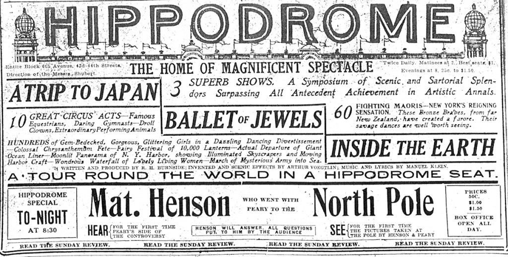
Peary also strenuously objected to Henson showing photographs made on the journey to the North Pole, claiming that Henson by contract was bound to turn over all of the photographs he had taken to him. He was so concerned about the picture of the Pole itself, that he wired, “If Henson, as newspapers say, has picture of NP, or the sledge journey he has lied to me, and these pictures must on no account be shown by him I doubt the papers.” The dispute with Peary was just the publicity Brady dreamed of, and he was now so sure that Henson’s lecture tour would be a success that he booked him at the Hippodrome for the evening of October 17.

Henson Hippodrome 2

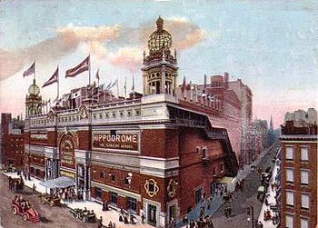
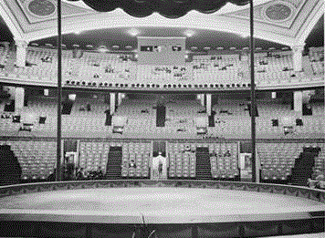
The Hippodrome was billed as the largest theater in the world; certainly it was the largest in the United States. Occupying an entire block on 6th Avenue between 43rd and 44th Streets, it was host to full-fledged three-ring circuses and other monster extravaganzas.

350px-Hippodrome_NYC_c1905_crop

Henson must have been awed to step onto the stage of this cavernous house, which sat up to 5,300. But the paying audience amounted to only about 500 scattered among a vast sea of empty seats.

large-2714989364

One of them was occupied by Herbert L. Bridgman, who Peary had dispatched to get a look at Henson’s photographs and generally do damage control if necessary. Bridgman didn’t seem too concerned by Henson’s performance, though he did say some unsettling things, including that Cook’s Eskimos, when they had first come aboard at Etah, had said that Cook had told them they had arrived at the North Pole [see the series “The ‘Eskimo Testimony’” below.]   After this fiasco Brady immediately canceled the two nights he had booked at Carnegie Hall, the turnout at the Hippodrome not justifying any hope for recovering the high overhead of that booking. Instead, he took Henson to Pittsburgh. But there and the farther west Henson went, the receipts continued to dwindle until Brady had to compromise his contract and pay him off.

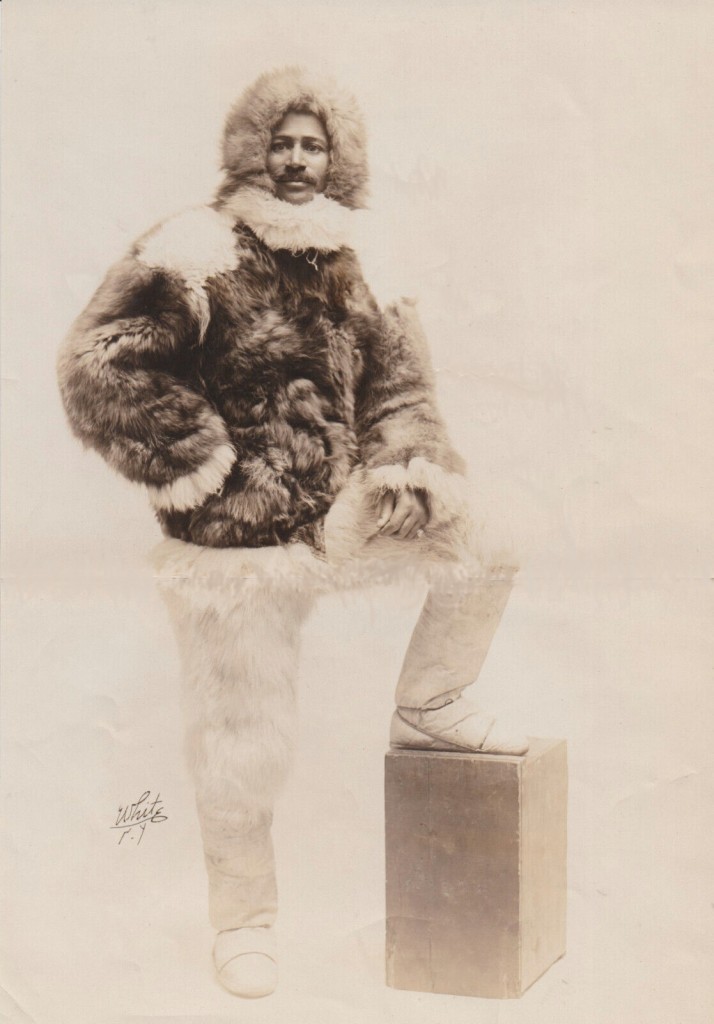
Matt Henson white 2

Matt Henson ready for the stage: Henson’s publicity photograph by White Studio, theatrical photographers

Nevertheless, Henson’s appearances had led to a number of revealing statements that became fodder in the ongoing Polar Controversy, and the building case against Peary actually having attained the North Pole, himself. Henson related that on the trip to the North Pole, Peary, because of his crippled feet, had been little more than baggage on the sledges, and that because Peary rode most of the way, Henson was in the lead when they arrived at the North Pole, technically making him the first man to have reached that fabled spot.

Peary was outraged, and assured General Thomas Hubbard, President of the Peary Arctic Club, that these and other reported statements were “all lies.” He complained to Benjamin Hampton, owner of Hampton’s Magazine, who paid Peary a record per-word fee for the magazine rights to his narrative, that “Henson, after my looking after him for years, after giving him a position in the advance party with me on all of my expeditions, and after permitting him to go with me to the pole this time, has now for the sake of few dollars deliberately and intentionally broken faith with me.” And to Herbert Bridgman Peary was unequivocal about what such “disloyalty” meant: “He has deliberately and premeditatedly deceived me and broken his explicit and thoroughly understood word and promise to me and I am done with him absolutely.”

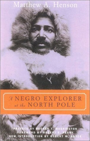
*For those interested in the documentary evidence of this statement, see the Introduction to the Cooper Square Press edition of Henson’s book, A Negro Explorer at the North Pole, published in 2001. 9780815411253-us-300-1942197860

All of the quoted correspondence, including the one published here for the first time, can be found among the Peary Family Collection, Record group XP, at NARA II.

Uncategorized

Dunkle and Loose get paid

May 15, 2024

This is the latest in a series of posts that publish for the first time significant documents related to the Polar Controversy.

Battle of Ink and Ice

In the latest book on the Polar Controversy, author Darrell Hartman focuses on the Press’ role in making the 1909 dispute between Cook and Peary a national obsession. He agrees with me that the resultant recognition of Robert E. Peary as the true discoverer of the North Pole, and the demise of Frederick Cook’s prior claim, was a watershed event in the history of New York newspaper publishing. Peary was backed by the New York Times, Cook by the then much more influential New York Herald. As I put it in my book, “the downfall of Dr. Cook marked the beginning of the rise of the Times to the powerful institution it was to become, and the decline of the once preeminent Herald into oblivion.”

Among the questions I was not able to answer in my book, Cook and Peary, the Polar Controversy, resolved, was whether or not Dunkle and Loose acted on their own, or were someone’s paid agents, hired to place the doctor in a compromising position (see my post for May 21, 2022 below). I was able to speculate from the evidence I saw, however, that if they were someone’s agents, as I wrote in my book, “The principal suspect would have to be William C. Reick,” an editor at the New York Times, the paper in which appeared their extensive affidavits about how they concocted fake observations at Cook’s request to serve as proof of his polar attainment. The affidavits were spread over nearly three full pages—by far the largest amount of space given a single story on a single day during all of 1909.

To many who read the Dunkle and Loose affidavits, the whole idea that Cook would enter so casually into so dangerous and risky an arrangement with total strangers seemed preposterous, the alternative monstrous and the conclusion obvious. As one newspaper editorialized; “Dr. Cook is either the greatest and at the same time the stupidest charlatan who ever attempted to impose upon a skeptical world, or he is the victim of the most malignant and devilishly ingenious persecution that hatred and envy could devise.”

Reick had a motive: he wanted to get even with James Gordon Bennett, the flamboyant owner of the Herald, where Reick had once been the powerful City Editor. But Bennett, ever wary of competitors for his absolute power over the Herald, kicked him upstairs by making him President of the New York Herald Company. Reick eventually quit and joined the Times. Among the many resources Hartman consulted for his book, were those in the New York Public Library, among them the papers of Adolph S. Ochs, long time owner of the Times. There he may have found at least a partial answer to whether Dunkle and Loose acted alone, or they were part of a larger plot.

General Thomas H. Hubbard (via a brevet commission from the Civil War), was the owner of the New York Globe and Commercial Advertiser, as well as the president of Western Union and a powerful corporate lawyer. He was also an alumnus of Bowdoin College in Maine, Robert E. Peary’s alma mater, and had been since 1908 president of the Peary Arctic Club, a group of millionaires formed in 1898 to bankroll Peary’s attempts to reach the North Pole. When the dispute between Peary and Cook over priority at the Pole broke out, Hubbard quickly grasped that Peary was not capable of managing the situation and became Peary’s official spokesman. He also financed a massive anti-Cook campaign, paying for such things as the Barrrill Affidavit, the Parker-Browne expedition to Mt. McKinley (see my post for July 17, 2017 below), and later, an extensive mail campaign to discredit Cook’s attempts to rehabilitate his claim to have reached the North Pole a year ahead of Peary. It now develops that he apparently also paid for the Dunkle and Loose Affidavits as well, though it does not seem to have initiated the scheme that led up to them.

That Cook had dealings with Dunkle and Loose there can be no question. Several close associates, including his private secretary, Walter Lonsdale, attested to that as a fact, but considered Cook’s dealings with them essentially innocent. But whether this scheme was the sole initiative of Dunkle and Loose, or that they were put up to it by a third party as a plot to destroy Cook’s claim by raising doubts in the minds of the panel just about to sit in judgment of the authenticity of his claim, as many newspaper editorials of the time suggested, is possibly answered by two documents Darrell Hartman recovered. Though not definitive, they strongly suggest that Dunkle and Loose initiated the plot themselves, figuring whichever way events might fall out, they would come out ahead.

I first learned of these documents during consultations Darrell Hartman had with me while in the final stages of preparing his book for publication.

The first document is a letter from George W. Dunkle to William C. Reick. Here is that letter, published for the first time with the permission of the New York Public Library:Dunkle_WCR_Letter_Receipt

Dunkle_WCR_Letter_Receipt 2Although unsigned, the handwriting is Dunkle’s. The content also confirms he is the author. In it he states “My business has been absolutely paralyzed and I am unable to move until this business is settled.” Dunkle was an insurance agent who lost his job due to the publicity surrounding his sensational affidavit.

According to his affidavit that appeared in full in the New York Times on December 9, 1909, Cook entered into an arrangement with Dunkle to pay him $2,500 for a set of fake celestial observations, to be provided by an indigent Norwegian sea captain named August Loose, “proving” that Cook had been at the North Pole on April 21, 1908, as he had claimed. Another $1,500 was to go to the pair if Loose’s calculations convinced the board of scientists of the University of Copenhagen, to which Cook had promised his data, and which was about to sit in judgment of his “proofs,” that his claim was authenticated by the evidence provided them.

In his affidavit, Dunkle said Cook reneged on his agreement and only paid him $260 before he broke off negotiations and checked out of his hotel without leaving a forwarding address. When his “proofs” were presented to the Consistory in Copenhagen by Cook’s private secretary in late December, they did not contain the observations Loose allegedly provided, however. In fact, they contained no observations whatever, and on that basis, the Danes rejected what Cook submitted as proof of his attainment of the North Pole.

Dunkle certainly must have seen that once he had broached his offer to Cook and Cook had entered into dealings with him, that he was in a can’t-lose position. If Cook went trough with the arrangement, and the Copenhagen panel was convinced by Loose’s calculations, he and Loose stood to make $4,000. If Cook backed out or refused to pay, they still had valuable evidence that they could peddle to the New York newspapers, the obvious first choice being the New York Times, which had exclusive rights to Peary’s first account of his North Pole journey and an editor who had a visceral hatred of his former boss at the Herald, which had the exclusive right’s to Cook’s account. Still, that does not preclude that this scheme was not part of a larger plot.

However, while the two documents don’t disprove Reick’s prior knowledge of Dunkle and Loose’s scheme, they strongly imply that once Reick was approached by Dunkle with his story after Cook reneged, that Reick then went to Thomas Hubbard, and it was his guiding hand, as it had been in all matters concerning the Cook-Peary dispute, that resulted in the eventual appearance of their affidavit in the Times’ columns. That Reick did not have prior knowledge of the scheme is also suggested by a letter I recovered from the Peary Family Papers at the National Archives, asking Peary for a sample of Dr. Cook’s handwriting, apparently to compare with what Dunkle claimed was Dr. Cook’s instructions to Loose as to what he needed in the way of fake observations, which was published in facsimile along with the Dunkle and Loose affidavits. This note to Peary was dated December 6, 1909, which would have been after Cook had checked out of the Hotel Gramatan, where his dealings with Dunkle and Loose were alleged to have taken place. Reick had previously cabled Peary on December 3 that he had “what I consider most important development yet,” suggesting that was when he was first contacted by Dunkle.

It is not stated in Dunkle’s letter to Reick who did the “grilling” it mentions. It’s true that many other newspapers noted with suspicion that this “scoop” appeared in the most anti-Cook of all newspapers, which had a vested interest in seeing Peary declared the victor in the ongoing dispute, but Dunkle’s statement that the Times also “grilled” him and Loose is certainly not applicable to what the Times printed. It is also doubtful that William Reick did any personal grilling, because the person to be satisfied that the story the Times was given by Dunkle was truthful in every respect was the “third man” paying for it, which the two documents Hartmann recovered together certainly point to as Thomas H. Hubbard. This is most forcefully implied by the content of the second document, a receipt and legal release, which states that the details of the affidavits that appeared in the Times were “made originally to Thomas H. Hubbard.” The “grilling” was undoubtedly administered on this occasion.

Hubbard had similarly “grilled” Edward Barrill, Cook’s sole witness to his claim to have been the first to ascent Mt. McKinley in 1906, before he published Barrill’s affidavit in the pages of his own newspaper, which stated that Cook’s McKinley climb was a hoax (see my series of posts on the Barrill Affidavit, beginning on June 13, 2022 below). Barrill had come to New York for that very purpose—to meet with Hubbard personally—and Hubbard managed Barrill’s stay in the city completely, ending it by sending Barrill back to Montana without him ever testifying before a panel appointed by the Explorers Club to look into Cook’s 1906 claim, where he might have said something that would contradict the affidavit Hubbard published.

The letter to Reick, although it bears no date, can be approximately dated from its content. Two weeks after the publication would have been December 23, and it is clear from the letter’s content that the Danes had already made their decision by the time it was written, which was announced on December 21. The letter must therefore have been written after December 23, but before they were paid.

Although the letter still leaves some details hanging, the second document supplies others. It’s a receipt and legal release, dated December 31, 1909, here published for the first time:Dunkle_WCR_Letter_Receipt 3

(Note: Brown Brothers & Co. was a private investment bank in NYC. It merged in 1931 to form Brown Brothers Harriman & Co.)

Its content definitely places the date of the letter before the last day of 1909 and leaves no doubt that they were paid well for their scheme, but perhaps not as well as they might have been. It’s interesting that the letter implies that Hubbard told Reick to withhold payment until the Danes decided on Cook’s proofs, suggesting that the amount Dunkle said he had “a gentleman’s agreement” –$2,000–might have been adjusted, depending on Copenhagen’s decision.

All along, Dunkle and Loose might have intended to play both sides of the street. Even if Cook had paid them a significant amount, or especially if the Danes had accepted Loose’s calculations as Cook’s originals and certified his claim to the Pole, the value of the story would have only increased, because revealing that the calculations that won their approval were Loose’s, not Cook’s, would have been iron-clad proof of Cook’s fakery. They might have then turned around and sold their story to the Times for an additional big payday. But Cook never used Loose’s calculations, and, in fact, no one to this day claims to have ever seen them after the face. But neither did he include them, or anything similar to them in the material he sent to Copenhagen in proof of his claim. Therefore, the value of their affidavits to Hubbard was severely diminished, and the final price they received was less than the amount Cook was originally to pay them, according to their affidavit. What they received is equivalent to about $76,500 today.

The documents shown here can be found at the New York Public Library in the New York Times Company Records / Adolph S. Ochs Papers, Box 77, Folder 3. Darrell Hartman’s book, Battle of Ink and Ice, is published by Viking.

Uncategorized

The Cook-Peary files: The “Eskimo Testimony” : Part 18: Why Cook went on.

April 5, 2024

This is the latest in a series of posts that publish for the first time significant documents related to the Polar Controversy.

There can be no doubt that Frederick Cook intended to make a real attempt to reach the North Pole. Numerous accounts by others recall him saying it was his “life’s ambition.” When not on an expedition, he devoted much of his spare time studying everything written about the polar regions and kept bound volumes of articles on the subject that he gathered from journals and magazines. While in Antarctica with Roald Amundsen in 1898 as members of Adrien de Gerlache’s expedition, he invented ingenious gear designed to be used in the polar regions and continued to do so, collaborating with his brother Theodore to build and test strong and resilient sledges made of second growth hickory, and experimenting with a motorized vehicle he hoped to use to reach the South Pole. The sledges were used with outstanding success by members of both Ziegler Polar Expeditions between 1903-05. And from his backer, John R. Bradley, he received carte blanche to equip his 1907 expedition with everything Cook thought necessary for an attempt on the pole in 1908.

Unlike Peary, who spent the winters before both of his last two attempts to reach the North Pole in his private, heated cabin of his specially built ship, Roosevelt, listening to its player piano, sampling his generously supplied cellarette, lounging in its full bathtub and enjoying the favors of his Inuit concubine, Allakasingwah, on demand, Cook, like Amundsen would do in Antarctica three years later, spent the winter in his house made of packing boxes, perfecting his equipment for his polar attempt. His very full diary that he kept during this time is replete with his preparations, experiments and trial runs seeking such perfection. He had also carefully worked out the route he would take onto the icecap of Ellesmere Island to descend into Cannon Fjord as a shortcut to reaching the Arctic Ocean via Nansen Straight, thus capitalizing on the abundant game encountered by Sverdrup on Ellesmere, but avoiding the obstacles Sverdrup encountered in crossing the island via Sverdrup Pass and Bay Fjord.

Unfortunately, all of Cook’s careful planning was upset by his inability to find an alternative route to Sverdrup’s, and he encountered not only the same delays, but the slaughter of game by his Inuit enroute further held him up to the extent that by the time he reached Eureka Sound he realized he could never get out onto the arctic pack ice soon enough to be able to reach the North Pole and safely return.

Cook was no fool. Upon his return, when a reporter informed him that John Bradley, a professional gambler himself, put the odds on Cook returning from his polar try at 100 to 1, Cook reportedly said that had he shared that view he would never have gone. “A man has no right to take such chances as that,” he said. So if Cook knew it was hopeless to go forward without any chance of actually reaching the pole even before he left Cape Thomas Hubbard, why would he have taken along two extra witnesses to begin with, and why would he have gone even an extra step farther after these two witnesses departed?

It must be remembered that although Cook was already a veteran explorer in both polar zones, he had never once even laid eyes on the polar pack of the Arctic Ocean before he arrived at Cape Thomas Hubbard. He had only read about it. True, he had made several short sledge journeys on the Antarctic pack of the Bellinghausen Sea while on the Belgica expedition, but he knew from his reading that the pack ice on the open Antarctic Ocean was much different in character from that in the largely land-locked arctic basin. He also knew from reading of the toils of Nansen and others who tried to reach the pole by dog sledge, the rigors of pack ice travel and therefore expected to be able to average no more than ten miles per day on such a journey. But he had never been on the arctic pack ice himself, so he needed to make a trip long enough to give him the real experience he would need to accurately describe the conditions he would encounter and get a practical estimate of how fast he could actually travel over the pack ice with the equipment and personnel at his disposal.

He could see from Cape Thomas Hubbard that he was in for some difficult traveling. It was only expedient that he take along two extra men to help him get through the jumbled ice pressed against the coast, two of whom had experience with Peary on the sea ice that Cook, himself, lacked. Even so, he found the first days he traveled from land with the four Inuit “difficult beyond any ice conditions which I have before experienced. Great paleocrystic floes interrupted by wide areas of young ice and miles of huge boulders and small ice the result of the grinding pack against the land.” Difficult or not, he needed more experience than that; he needed to experience the ice conditions on the “circumpolar sea” away from the influence of land. Although he knew the North Pole was beyond his reach, that is why he would be willing to continue to the northwest after Inugito and Koolootingwah had helped get him over this rough stretch. He also might have hoped to reach “Crocker Land” and explore part of it, cache supplies there for a future attempt, or make a discovery that confirmed the “unknown Arctic Continent” scientists hypothesized lay in the vast unexplored region to the northwest.

Unfortunately for him, once over the rough ice thrown up against the shore, Cook traveled over a most atypical stretch of ice lying over a “current null” zone, which in spring made the ice unusually stable. This allowed him to make excellent progress until he encountered the shear zone caused by the then-unknown Beaufort Gyre about 100 miles to the northwest of Axel Heiberg Island. There he, and MacMillan after him, encountered the chaotic ice that stopped such progress and sent them back to land, in MacMillan’s case because he had already proved Crocker Land did not exist, and in Cook’s because he had obtained the experience in ice travel he had sought, and because to go further would take him out of sight of landmarks he needed to guide him safely back to shore. He, like MacMillan, saw no reason to go on. The ice conditions were too difficult and the season too late. So Cook took his experience and turned back for the bank of clouds still visible over Grant Land.

That experience paid big dividends in making his eventual description of his polar journey vividly realistic to many readers of My Attainment of the Pole, and consequently his claim to have reached the North Pole plausible. Even the book’s critics recognized this. As one hostile reviewer wrote of his descriptions of his journey as presented in the pages of Hampton’s Magazine in 1911, “This is vivid and real. It is not imaginative literature. It is obviously descriptive of actual and unusual experience. As such the record is worth preserving, irrespective of the writer’s reputation of veracity, which as the newspaper comment seems to indicate, is irremediably lost.” And when Cook’s book was published in Germany, one reviewer wrote, “It can be no lie what this man lets us experience, and even if it is a lie, it has earned a place in every library.”

But Cook’s experience, being atypical of general ice conditions on the Arctic Ocean, actually led him to underestimate the difficult character of the ice between the land-adhering ice and the pole and to assume that a greater rate of progress could be made than had been reported by other travelers. He may have believed, given the accepted scientific theories of his day, that along his chosen route, far west of other attempts, the supposed “Arctic Continent” that caused him to postulate the position of the non-existent “Bradley Land” and his “Glacial Island” would have a moderating effect on the easterly drift reported by others and, consequently, on the ice disruption that those explorers who traveled farther to the east experienced. This is supported by Cook’s statement on page 96 of My Attainment of the Pole, as he looked out across the pack from Cape Thomas Hubbard:

“I viewed for the first time the rough and heavy ice of the untracked Polar sea, over which, knowing the conditions of the sea ice, I anticipated the most difficult part of our journey lay. . . . Beyond this difficult ice, as I knew, lay more even fields, over which traveling, saving the delays of storms and open leads, would be comparatively easy.”

Thus he felt safe in claiming more progress per day than he had expected before he had made a journey onto the sea ice himself, because his passage over the atypical current null zone seemed to confirm what he “knew.” However, there is no “Arctic Continent,” no “Crocker Land,” no “Bradley Land,” and other travelers since 1908 have found that there is little consistency to conditions encountered on the Arctic Ocean. Some reported areas of relatively smooth ice, while others at the very same latitude years later reported a chaos of impassible pressure ridges and hummocks.

Another reason for going on was purely practical; he had to make some attempt to convince his witnesses, the Inuit who accompanied him, that they had reached what they called the “Big Navel.” Cook certainly knew, as Whitney discovered, that the Inuit had difficulties estimating distance, a concept they did not need to consider because they never willingly made journeys that took them out of sight of landmarks or beyond the game haunts which were central to their way of life. Therefore they couldn’t conceive the distance to the North Pole, or where exactly it lay, nor did they care about reaching it. But they knew from Peary’s several attempts that it lay to the North, out over the frozen sea. So Cook had to make a journey north over the sea ice if he wanted to claim to his witnesses that he had reached the North Pole.

A third reason to go on was that Cook needed to get some photographs of his two sleds traveling alone over the pack ice and igloos built on the ice pack for his future lectures. Most of the pictures taken after his support party left do not show very rough ice, either confirming the relatively easy traveling conditions he had over the null zone or that they had been taken elsewhere.

But the final reason was the most crucial: Cook needed to stay out on the ice long enough to allow Koolootingwah and Inugito to get on their way back to Greenland. They were in a hurry to get home but might linger at the cache at Cape Thomas Hubbard to feed their dogs and themselves before going on. As Cook states in his original notebooks, he planned to return by a “shortcut” across Arthur Land, via Cannon Fjord, and so had laid a cache in Greely Fjord. This would also minimize the chances of running into any of his Inuit helpers before he returned to Greenland, because in laying that cache in “Flat Sound,” he assured that they would not return by another route. In doing so, he discovered that Shei Island was actually a peninsula. None of these were actions that an explorer intent on reaching Cape Thomas Hubbard as quickly as possible would have taken. Rather, all these caches were aimed at separating his return route from that of his support party on the way back to Greenland. This was critical in a hoax, as any premature sighting of the polar party by others would lock him into a known timetable and limit what he might claim later. Therefore they indicate that he had in mind the idea of perpetrating a hoax as soon as he saw it would be impossible to reach Cape Thomas Hubbard in time to give him any chance of actually reaching the North Pole and returning safely. In fact, his original notebook itself supports this notion, because it is exactly as Cook turns into Cannon Fjord that the original entries are most tampered with and many even destroyed to obscure the true sequence of events thereafter.

Unlike other explorers, Cook had taken care not to leave any dated records along his route to the same purpose. He must stay away long enough to give the illusion that enough time had passed for him to have been to the pole and back. He left just one dated record—the letter he sent back with the Inuit to Franke, which he dated March 17. His statements in this letter that he expected to be back by the end of May, or June 5th at the latest, and his stated anxiousness to go to the Danish settlements immediately upon his return indicate that at the time he wrote the letter (probably about April 15) he hoped to do just that. But after his brief experience on the polar pack ice, he must have reconsidered. On page 203 of My Attainment of the Pole, he said as much:

“Although we had left caches of supplies with the object of returning along Nansen Sound, into Cannon Fjord and over Arthur Land, I entertained grave doubts of our ability to return this way. I knew that if the ice should drift strongly to the east we might not be given the choice of working out our own return.”

This is an amazing revelation in itself, in that Cook does not mention or even hint at his plan to return via Cannon Fjord and Arthur Land elsewhere in any of his published writings, though he makes this quite explicit in his notebook’s narrative, and states there that he laid a cache in Greely Fjord, far off his published route, to this purpose. It also hints that he saw that to claim that he could reach the pole from the position stated in his letter dated March 17 and get back to Greenland by June 5 would have been absolutely incredible. So he decided upon an alternate plan: He would not go back to Greenland at all.

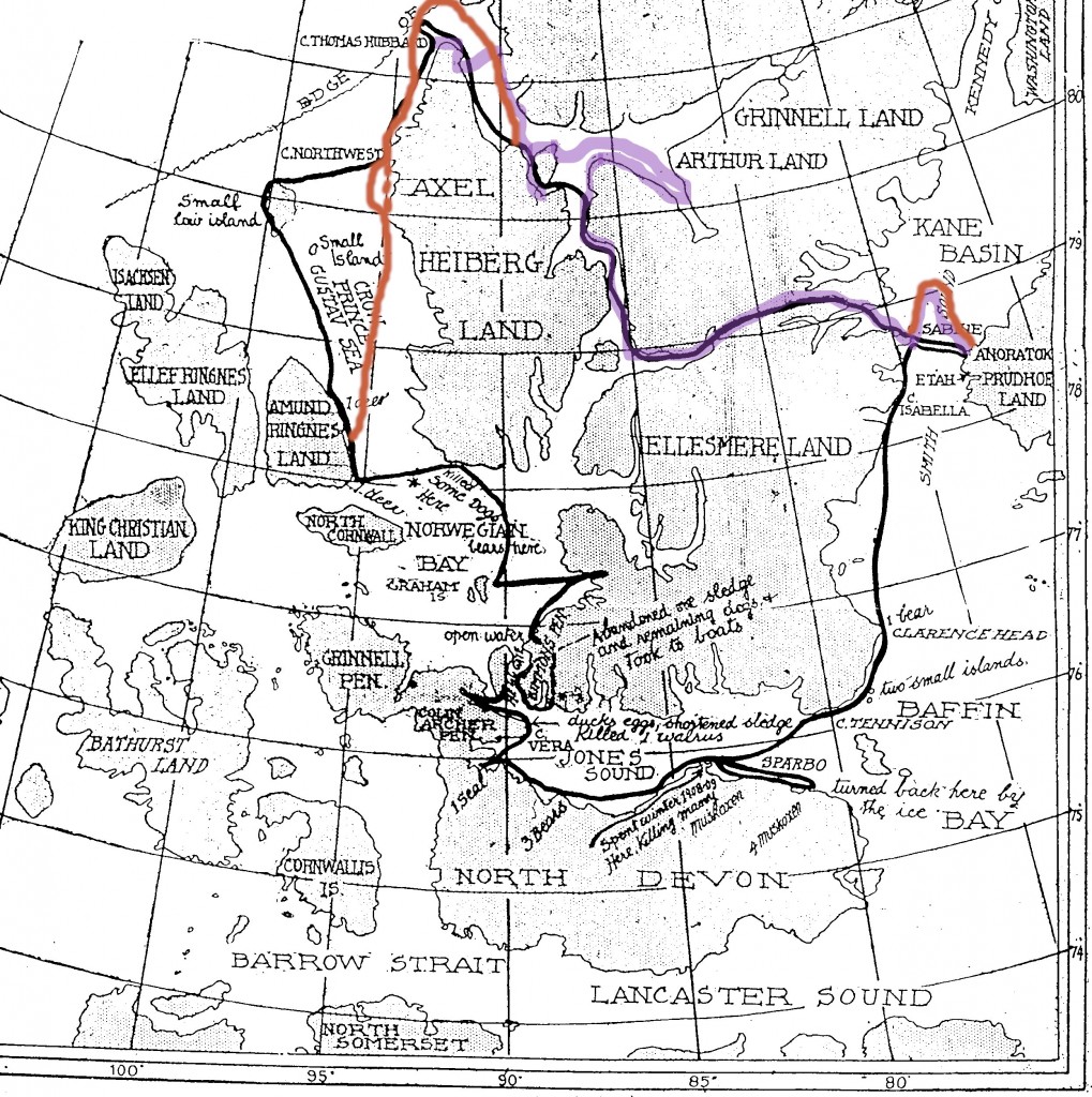
Instead, he would go south, along the uninhabited western coast of Axel Heiberg Island and by a roundabout route attempt to reach Lancaster Sound. There, Cook knew, whalers from Dundee, Scotland, visited every year without fail. Everyone who followed arctic explorers, and many who didn’t, were familiar with Nansen’s dramatic chance meeting with Frederick Jackson on the desolate shores of Franz Josef Land in the spring of 1896. It caused an absolute press sensation. What better way to maximize interest and lend authenticity to his own tale than to have a similar “chance” meeting with a whaler and be taken back to Europe in the fall of 1908, a full year before Peary could possibly return and put in a claim? In preparation for such a meeting, Cook, against his Inuits’ vigorous objections, even abandoned his dogs and one of his sledges and took to his folding boat once he reached Jones Sound so as to look as though he had been on an arduous journey. But his plan failed. He got only as far as the end of Jones Sound by late August, and so never could make his planned “accidental” rendezvous. By then, he also could not hope to return to Annoatok before winter set in.

Having noted the rich game lands near Cape Sparbo, he backtracked along his outward route and settled down for the winter in a comfortable underground shelter after shooting all the game he needed with the ample ammunition he had taken with him from Cape Thomas Hubbard. Once settled, in retrospect, he probably was just as happy that he had to overwinter. What could be more convincing than that? What faker would spend a “Stone Age” winter with only a couple of “savages” as companions, when he could have perpetrated his hoax much more easily by returning along his outward route to comparative civilization? Since Cook had a rich inner life and an infinite capacity for self-expression and embellishment of his already extraordinary experiences, he no doubt was content to have the winter to try out his story in his five unused notebooks and with each successive version, perfect the details he would tell the world upon his return. Such a course of self-isolation, and such a fabrication as his notebooks show evolving in meticulous detail in tiny writing, sometimes several lines to the rule, might not have been possible for an ordinary man, but Frederick Albert Cook was no ordinary man.

Cook had an amazing capacity for work, which was evident during any enterprise he undertook. This can be seen in his toils in several occupations as a youth, in his estimable medical service on Peary’s and de Gerlache’s expeditions, in his voluminous studies of polar literature, in his endless travels on the lecture and vaudeville circuits, in his work as an oil promoter and in his almost single-handed writing of the prison newspaper at Leavenworth. Cook’s polar notebooks show that same amazing capacity, as he put version after version of his journey down on paper in minute writing by the light of a blubber lamp in his winter igloo at Cape Sparbo, and as he made a draft of the book he would write asserting his attainment of the North Pole. In addition to all his talents, Cook had a very high degree of self-confidence that led him to feel he could actually attain the mythical spot that so many had failed to attain, and when he himself failed in his well-planned, genuine attempt to do so, to believe he could convince the world that he had through his experienced-based, but imaginative writings.

This concludes this series on “The Eskimo Testimony.”

Uncategorized

The Cook-Peary files: The “Eskimo Testimony” : Part 17: Tracing Cook’s actual route: Part 4: How far did he go?

March 13, 2024

This is the latest in a series of posts that publish for the first time significant documents related to the Polar Controversy.

We have now come to the penultimate installment of this series, having examined the first leg of Cook’s journey from Annoatok to Cape Thomas Hubbard and the third leg of his journey from his return to land until he again reached Annoatok. We have seen that as far as the first leg is concerned, when compared to documentary evidence, Peary’s alleged Inuit account is demonstrably incorrect in many crucial respects, whereas in the case of the third leg, compared to more limited documentary but significant circumstantial evidence, Peary’s statement is borne out to a much larger extent than the route claimed by Dr. Cook. Between these two legs lies a gap covering the period Cook was out on the sea ice north of his starting place at the tip of Axel Heiberg Island.

There is no question that Cook left land. Every witness, and even Peary, conceded that. The only questions to be settled are in what direction he went, how long he remained away from land, and how far he traveled during that time. The first of these is easily dispatched: when he left land he went to the northwest, not due north. Cook, himself, and every account that touches on this part of his journey, including Peary’s, are consistent on this point. But why?

It appears that he took this direction for several reasons. As his erroneous celestial observation sights published in My Attainment of the Pole prove, and all other relevant evidence, including his conversation with Alfred de Quervain show (see Part 6 of this series) Cook never mastered the navigational skills necessary to find the North Pole, including the use of a sextant. This seems incredible, but is evidently true, nonetheless.

He was an avid reader of anything that had to do with the polar regions, collected everything published on the subject, and even had those articles bound into books for future reference. Cook, who was described by one associate as “ingenious and impractical,” said that in these readings he had found a simple way to reach the North Pole by compass alone. After studying the data published by Nansen and Sverdrup, he surmised that near the 97th parallel there was what he termed a “magnetic meridian” (actually an isogonic line) where the needle of a magnetic compass would point 180° out of true. In other words, once on this “magnetic meridian,” the compass’s needle, instead of pointing due North, would point due South, enabling him to reach the North Pole by following his compass due South, dispensing with the need to take celestial observations with a sextant. Or so he thought.

This was an idea Cook believed the rest of his life, even mentioning it in the “Author’s Note” to his posthumous book, Return from the Pole, written in the 1930s. But it was not that simple, though Cook never understood why, because once reached, it would have been impossible to stay on his “magnetic meridian” without frequent checks of his position via a sextant. That isogonic line, if not on the 97th parallel, did lie somewhere to the northwest of Cook’s starting point. But another reason he might have chosen such a course also came from his extensive study of polar-related scientific literature.

At the time of Cook’s expedition, a large part of the Arctic basin had never been explored. There was a strong belief in some scientific circles, based on observations of natural phenomena in the high arctic, that there lay in that unexplored region above Canada and Alaska undiscovered land or possibly even an “unknown continent.” Through his reading, Cook absorbed this belief. As early as 1900 he wrote: “It seems reasonable to expect some rocky islets north of Greenland as far as the 85th parallel, surely to the 84th. If stations were placed here there would be only 360 miles to cover [to reach the pole].” Up to the moment he left Annoatok, he had this idea in mind. Before he departed, he left two letters (both dated February 20, 1908—the day after he later said he left for the pole!), one addressed to Knud Rasmussen and the other “To whom it may concern.” The one to Rasmussen mentioned that “There is also a strong possibility of our finding much land to the westward of Crocker Land,” and that he might return via the newly discovered lands to Alaska instead of Greenland. If he could go far enough to make such a discovery in the area that many scientists believed already held unknown land, it would be a major scientific result of his expedition and also might serve as a way station to replenish supplies on his return journey from the North Pole or act as a stepping stone for some future attempt to reach it. And if an actual “unknown continent” existed, it might mitigate the generally easterly drift reported by earlier explorers, and possibly also shield his route from the extreme disruptions to the pack ice experienced by others who had tried to approach the pole from routes much farther east, including Peary’s 1906 attempt, on which he was nearly swept past the top of Greenland and out to sea. Peary’s report after that expedition that he had sighted from the heights of Cape Thomas Hubbard a new land lying about 120 miles northwest, which me called “Crocker Land,” only strengthened Cook’s belief that a course to the northwest would have many practical advantages.

We have it from Cook that the two additional natives accompanied him for three full days, but did not sleep at their camp at the end of the third day, but instead started for home. Peary’s statement is incorrect on this point, because it is confirmed by one of those Inuit, Inughito, in the notes taken down by George Borup (see Part 4 of this series). One of the many oddities of My Attainment of the Pole is that Cook doesn’t mention taking the two extra natives until after he has already gone two days from land. He does claim, however that he made two of his longest marches with their assistance.

Although MacMillan’s later accounts differ in detail from that which Peary published, he signed his name to Peary’s as a true account of what Cook’s Inuit said in 1909. So if we consider Peary’s published account the first account they gave him, and the one closest to the events being described, this contradictory evidence demands a careful reading of the rest of it, similar to that done by Captain Hall (see Part 10). Peary’s published account, although it does not say so explicitly, as Captain Hall discovered, implies Cook traveled at least four days on the ice away from land in addition to whatever time it took to return, and indeed, its vague language does not rule out an even longer stay on the ice than that. However, how far he actually traveled is difficult to determine because there is no consistent evidence in any of the subsequent reported accounts of what Cook’s Inuit companions said except that all of them claim the Inuit said they were never out of sight of land.

Of course, Cook himself said he left land on March 18 and traveled all the way to the North Pole and back between that date and June 13. So, let us be clear on this point from the very start: although how far he traveled is uncertain, Frederick Cook did not reach the North Pole. This was not, however, because, as Peary implied, he had inadequate equipment or supplies to do so, but because by the time he reached his jumping off place he had already run out of the most important commodity of all on such a trip: Time itself.

A careful analytical study of his original field diary kept on the first leg of his journey which I recovered from Denmark in 1994 (see the author’s The Lost Polar Notebook of Dr. Frederick A. Cook), and the account written by Rudolf Franke, Cook’s only civilized companion over the winter, shows that he left Annoatok, not on February 19 as he claimed, but a week later, and that he was delayed en route to the extent that he did not reach Cape Thomas Hubbard until about April 13. Cook knew starting for the pole that late would be untenable with the advance of the season, and his claim to have attained it on April 21, just 8 days after he left land, would be, of course, impossible. His delays en route were not due to poor planning, however.

The diary he kept over his winter at Annoatok, now at the Library of Congress, shows that he fully intended to make an actual attempt to reach the pole. Many of his preparations show that he had been theorizing this attempt for years, had made careful and practical plans for his attempt, had adequate equipment and supplies, and strongly refutes any argument that his expedition was some sham from the beginning designed to cover up an already premeditated plan to make a fraudulent claim of success. Although he left a week later than he claimed in My Attainment of the Pole, his diary indicates that he nevertheless left at the earliest possible time that he could, considering weather conditions and logistical necessities. Likewise, his tardy arrival at his place of departure from land was not due to poor planning, either, but instead to two uncontrollable factors: the actual physical conditions he encountered en route, and the fact that he was traveling with a large group of Inuit.

Cook had studied Sverdrup’s book, New Land, in detail, and hoped to shortcut Sverdrup’s route to Nansen Sound by reaching the icecap of Elllesmere Island, and from there descending into Cannon Fjord. Unable to do this because of the impossible terrain, he was forced to follow Sverdrup’s route and encountered all the same impediments Sverdrup had described in his crossing Ellesmere to Bay Fjord in 1899: little snow cover on the pass, and a glacier that blocked access to the route of descent into the fjord. He was delayed five days by the glacier alone. But his Inuit companions were his major source of delay. Although they were indispensable to Cook in getting him safely to his jumping off point, Inuit in those days could not be hurried. They had no concept of such things as “deadlines,” or such abstractions as “the North Pole” and the time limits on when a successful trip had to begin for one to reach it and return alive again.

As far back as Charles Francis Hall, who in the 1860s was the first explorer to adopt Inuit culture and travel with them, explorers were frustrated by their inability to impress Inuit with such abstract goals as they were pursuing. They were slowed by the Inuit propensity to keep to no time schedule, and were thus forced to travel instead at the Inuit’s own pace. As Wally Herbert found out by his experiences with Inuit in the mid-1960s, little had changed since Hall’s time: “Unlike most Europeans, they do not regard the Arctic as a setting in which to test themselves, they are the Inuit, the real men, and never in a hurry.” But Cook was in a hurry.

He knew that to have any realistic chance of reaching the North Pole every day counted. He had estimated a round trip of 80 days from Cape Thomas Hubbard, so he had no time to lose to begin his journey at the earliest possible moment. But his Inuit were not explorers; they were hunters, first and foremost, and whenever game was encountered they slaughtered it. After slaughtering it they dressed it carefully and cached what they and their dogs did not eat for future reference. These procedures took time—in the case of musk oxen kill, a full day or more. As they encountered herds of these animals as well as polar bears along their route to land’s end, they thus moved at the Inuit hunter’s unhurried, age-old pace. This caused Cook’s time schedule to continue to slip, so much so, that by the time he reached halfway up Eureka Sound he knew he would arrive too late at the shore of the Arctic Ocean to have any reasonable chance of reaching the pole.

Cook’s detour into Greely and Cannon Fjords to lay caches for his return to Greenland, instead of taking the direct route up Nansen Sound Peary mistakenly attributed to him on his map, were errands no explorer bent on reaching the pole would have gone on, and they show that it is very likely that by that point, Cook was at least considering a false claim to have reached the North Pole.

With the pole out of the picture, two questions still remain: how long and how far did Cook travel on the sea ice after leaving land, and why, if he knew he had no chance of success at the pole, did he hazard any journey away from land at all? The first question has at least some evidence we can consider; the second is one that can be only speculated on, given our knowledge of subsequent events. But it must be stated right here, before beginning, that the answer to either question cannot be given with a great degree of certainty. The answers proposed here are therefore the author’s considered opinions only, not statements of fact, because as we stated at the very outset of this series, it is impossible to “prove” an unwitnessed assertion, which is what Cook’s claim of polar attainment is. But every opinion given here is based on evidence, nonetheless. So, let’s consider the evidence bearing on the first question, first.

As we have seen (Part 13 of this series) the Inuit story about their journey with Cook changed. At first, anyone who heard Inuit gossip along the Greenland coast in 1909 from Nerke to Umanaq Fjord, consistently and without exception heard that Daagtikoorsuaq and two Inuit had reached the North Pole. That changed when Peary arrived there in August. Then the consistent story became that they had not been out of sight of land, and, therefore, Cook could not have reached the pole, which lay hundreds of miles from any known coast. That change came when Etukishuk and Ahwelah realized “what Peary’s men wanted them to say.” Henson, their interrogator himself, confirmed this: “[Dr. Cook] ordered [his Inuit] to say that they had been at the North Pole, [but] after I questioned them over and over again they confessed that they had not gone beyond the land ice.”

But the change of their story may actually represent something else, besides “ilira.” They at first probably believed that they had reached the North Pole because Cook had told them so. Why would he have turned back if he hadn’t? Furthermore, according to Rasmussen, Cook had shown signs of elation and “jumped and danced like an Angekok when he had looked at his sun glass and saw that they were only one day’s journey from the Great Nail.” (as quoted in “The Witnesses for Dr. Cook,” by the then United States Minister to Denmark, Maurice Francis Egan, which appeared in The Rosary, v. xxxv, no. 5 (November 1909)). After camping there several days he started back voluntarily, although there was “no need to turn back because the ice was good.” They understood generally that the North Pole lay out over the ice to the North, but not just how far, and Cook had gone an entirely different direction than Peary to get there.

Harry Whitney, who lived and traveled with the Polar Inuit for a year, has many insightful and sympathetic things to say about them and their culture in his book, Hunting with the Eskimos. Whitney noted that Inuit, although they had a good sense of direction, were not good at judging distances, and in the light of the never-setting summer sun, divided periods of effort into “sleeps” instead of days:

“Four “sleeps” indicated nothing. It might have meant two hundred miles, or it
might have meant 50 miles. The Eskimo has no conception of distance. He is
endowed with certain artistic instincts which enable him to draw a fairly accurate map
of a coast line with which he is thoroughly familiar, but he cannot tell you, even
approximately, how far it is from one point to another. Often when they told me a
place we were bound for was very close at hand, it developed that we were far from it.
This is something they are never sure of and cannot indicate.”

Cook certainly knew this, so he knew that the Inuit had no conception of the distance to the North Pole. Abstractions like the North Pole meant nothing to them anyway, so they had no interest in the place themselves and were not eager to go far from land in any case. They probably begged Cook to return, as Pewahto would MacMillan in 1914. They would be satisfied by Cook’s mere statement that the goal had been reached, and then would happily return to the safety of land and to their families on home shores, where they would collect their pay. In 1909, Ahwelah and Etukishuk shared with other Inuit Cook’s statement to them that they had reached the “Big Navel,” but in 1914, when MacMillan had shown them on the map in My Attainment of the Pole where Cook said he had gone with them to reach it, they had a good laugh over it. Even with “no conception of distance,” they could see they had not traveled that far north. After that, the Inuit nicknamed Cook “The Big Liar.”

Peary’s statement does not attribute any estimate of the distance they went form shore at all. There were some later estimates given, ranging from 12-25 miles, but Peary’s statement only said they were never out of sight of land. Of course, this precludes that Cook actually reached the pole, but we have already ruled out that possibility by documentary evidence. If the Inuit told the truth, how far could Cook have gone and still not have been “out of sight of land”? For a definite answer to this question we must turn forward five years to MacMillan’s experiences on his attempt to reach Crocker Land in 1914 (see Part 6).

In his 1914 letter to Brainerd, MacMillan states that he lost sight of Grant Land at about 75 miles from shore, and in his book, Four Years in the White North, he said it was 78. In his original diary, now at the American Museum of Natural History, he says he was at this position on his sixth day of travel. He also states there that the next morning he thought he saw land in the morning to the west, but it proved to be only a mirage. After going on two more days he was stopped by chaotic ice. At that point MacMillan placed his party’s position at 106 miles northwest of their starting point by dead reckoning (DR), but a celestial observation gave their position as 120 miles from shore. (In his book, MacMillan says this observed positions “agreed almost exactly with out dead-reckoning,” but this is not true. Other details in his book are also at variance with his original diary.) They then attempted to go on the next day, but the ice was so impossible they made only a few miles before giving up, because they were already beyond the supposed position of Crocker Land and nothing was in sight. They had been on the ice 8 days at this point and had averaged about 15 a day by observation, not counting their last few futile miles. [all mileage figures are in Nautical Miles, 60 of which equal one degree of latitude]. However, when MacMillan published his book about the Crocker Land Expedition, he claimed his traveling companion, Ensign Green, had “recomputed” their position at the time they turned back and found that instead of 120 miles, they were actually 150 miles away from their starting point. That ups the mileage to 18.75 miles per day.

Let us now compare Cook’s various accounts of his journey on the sea ice in 1908 to Macmillan’s. There are four sources of data: #1: a Cook diary containing an incomplete circumstantial account; #2: Cook’s field diary that he kept on the first leg of his journey, which also contains a series of sequential notes covering his entire time on the ice; #3: his narrative account of his entire trip in My Attainment of the Pole and #4: his so-called “copy of the field notes” he kept on his journey, which were published as an appendix in that book. But first, a few words about the two manuscript sources.

#1 is an account covering the 6 days from March 18-23. The first entry is dated March 20, and summarizes that day and the two previous. This account is most similar in appearance and format to the separate diary Cook kept from the time he left Annoatok until he reached the point from which he headed out over the sea ice (#2). The size of its writing, the style of narrative, the data included and the incidental events described are all similar to the record he kept from leaving his winter base until he reached Cape Thomas Hubbard in that notebook. The “field notes” in that same book, on the other hand, contain entries for each day starting with March 19 and ending June 13, 1908, and continue that account, but the size of the writing and their format is entirely dissimilar. #1, starting on March 20, is consistent with the regular daily entries in his field diary kept on the first leg of his trip, but not with other diaries kept while Cook was not in the field. Nor is it consistent in content with either his “field notes” or the narrative account in his book. These “field notes” are in very small writing and are in the style of telegraphic phrases with little narrative content at all. And there is yet another contradictory source in the form of a “copy” of his published field notes, but, suspiciously, that also has entries for the days from February 19-March 18, not in either version of the so-called “field notes.” These additional entries do not match those in his original narrative notebook (#2).

After examining all of the diaries Cook wrote while on his expedition of 1908-09, the author concluded that the “field notes” in #2 were probably written, not during the time they describe, but during the period Cook overwintered at Cape Sparbo, or possibly even later—the period during which the Inuit remembered he “wrote and wrote.” For all of these reasons, the author is of the opinion that #1 is an actual field record of the first six days of his journey away from land, and that the other sources are after the fact or imaginary accounts. Here is a table comparing the content of the overlapping data these four sources contain, with an extra column with the relevant data from MacMillan’s original field diary:

Table 1

Table 2A couple of things to notice in this comparison: The diary (#1) mileage total is the lowest. If this was an actual record and Cook was claiming the pole, in inventing a false narrative going all the way to the pole, he naturally would want to adjust his mileages upward for these days with each successive rewrite so he could reach the pole on April 21 with a reasonable daily average mileage. Notice that this is the exact pattern of the four successive accounts (if the author’s opinion of the sequence in which they were written is correct), the highest being his eventual published narrative. This is the pattern of fudging that is clearly demonstrated in his adjustment of dates in his field diary (#2) kept on the first leg of his trip. Also, notice the conflict on March 23 in his narrative account. The first five days in his “field notes” add up to 92 miles. On March 22 he says he went 22 miles. At the end of the sixth day in his narrative he gives no mileage for the day, but he says the first 100 miles have been covered, implying 8 miles for this day, but his statement that he had two marches in a row adding 50 miles to his total gives a figure of 28 miles for that day. And later in My Attainment of the Pole he says, “The goal lay 400 miles away,” which rules out the smaller figure.

All four accounts are consistent in saying that Grant Land (the name then in use for the uppermost portion of Ellesmere Island) was still visible until the end of the fourth day out. That would be at 82 miles in the diary (#1) account, or 92 in the other three. For the fifth day, #1-3 add a further 22 miles to this. But #4 because of the conflict noted above, is ambiguous. Only #2 and #3 are in agreement for March 23. These are the kinds of inconsistencies that are the mark of invention, not the recording of actual events as they happened. And because of the curvature of the Earth only the first and lowest figure of 82 miles would be possible if the observed point on Grant Land was not raised by refraction.  Therefore, in many respects there is reason to believe that #1 is probably a genuine account of Cook’s first six days on the ice (and even it has insertions and deletions within the original text. The reader can find a complete transcription of this diary account on pages 969 to 973 of the author’s book, Cook & Peary, the Polar Controversy, resolved, which shows these changes as well).

Since Cook was not traveling due north, but slightly west of north by his own account, he would have been traveling more miles to make the distance between the two latitude readings he gives. In his book Cook describes his method of deal reckoning: “We were traveling about two and one-half miles per hour. By making due allowances for detours and halts at pressure lines, the number of hours traveled gave us a fair estimate of the day’s distance. Against this the pedometer offered a check, and the compass gave the course. Thus, over blank charts, our course was marked.” Notice that he says his course is determined by compass alone, but he never mentions any corrections for magnetic variation. If a traveler doesn’t know what that is, then any course set solely by compass can’t be accurate. This implies he is acting on his untenable idea of being on his “magnetic meridian,” which he believes lies approximately along the 97th parallel. As long as one has sight of a point whose bearings are known, such as Grant Land, one can steer an approximate course, but such a “system” of navigation is pure guesswork without such a bearing, and so anyone traveling out of sight of land would lose all points of reference for direction. This alone, for any sane traveler, suggests that Cook never really would have gone out of sight of land.

No matter what figures MacMillan gave in his various accounts, MacMillan found his own dead reckoning was always less than his celestial observations indicated. And the difference between the two was quite significant in their final sight whee they turned back and even more so in Green’s later “recomputaion” of it. MacMillan and Green probably didn’t travel much farther than what their DR indicated, and possibly even not that far.  And they possibly had reason to want to inflate the distance they traveled. They wanted to make sure they traveled beyond the assumed location of Peary’s Crocker Land, but reading their diaries, one feels that they were very eager, because of the failing condition of their dogs, to turn back as soon as soon as possible. Not only were their dogs dying in the traces, the season was advancing and the Inuit were urging them to “turn back as Dr. Cook had.” In this there is the suspicion that MacMillan and Green, like Cook, were adjusting their mileages upward as well, perhaps to assure others that their trip undoubtedly covered the distance necessary to assure that Peary’s Crocker Land had no existence at its estimated position. In his published narrative, MacMillan leaves open the possibility, for instance, that it might lie farther off shore than they expected. But, intentions aside, we have, like Cook’s various accounts, only their positional data to guide us, and like Cook’s, that varies considerably from account to account.

If we just accept the difference between their first estimate of their final celestial observation and their DR figure of 106 miles, their DR was out by -12%. So if MacMillan said that they were still able to see Grant Land at a distance of 75-78 miles DR, adding 12% to that means it was visible at 84-86 miles. This matches up quite well with Cook’s statements of the distance he lost sight of it in #1’s diary entries, that seem to be an actual record written in the field. If you take Green’s recomputation to be valid, their DR was off by -30%. That means they would have to add 22 ½ miles, making the distance at which Grant Land was visible 97-99 miles. However it is doubtful, even with extreme refraction, that Grant Land could possibly be seen at that distance.  However, Cook was traveling significantly farther to the east, along the 97th Meridian, than MacMillan, at the 108th at his last observation.  So Cook would have been much closer to Grant Land than MacMillan, and therefore would have a much better chance of keeping it in sight longer.  This raises the possibility that Cook could have been at least as far from shore than #1 claims without being inconsistent with the Inuit statement that they were never out of sight of land.

The various estimates of Cook’s distance from shore when he turned back given by MacMillan (see Part 6 of this series) range from 12-15 miles, and Henson estimated 20-25. The Inuit gave no estimate in Peary’s statement. However, in Borup’s notes, Etukishuk gave his own estimate that the distance he traveled with Cook was not as far as he had gone with Matt Ryan in 1906 (see Part 5). On Peary’s failed attempt to reach the North Pole that year, Ryan had headed one of Peary’s support divisions that he sent back in stages as the expedition drew away from land. Ryan stopped at the so-called “Big Lead,” where Peary was delayed by open water for one week. This was by observation located at 84° 38’, 115 miles north of Point Moss. This suggests Etukishuk thought that the distance he traveled with Cook and with Ryan were similar, but that he felt Cook’s was the lesser of the two, or he would not have made such a comparison, because even though Inuit had trouble gauging distances, 12-15 miles is hardly comparable to 115. Of the totals of the three accounts in the table, only the #1 diary account is less than Ryan went—one mile less, but none of the others are hugely incomparable.

MacMillan’s attempt to reach “Crocker Land” was the nearest contemporary journey to the northwest from Cape Thomas Hubbard after Cook’s. No one had every traveled before over the route MacMillan took, unless it was Cook. MacMillan’s experiences are not in dispute, though his various accounts of it, like Cook’s, are not consistent in every detail, either. Therefore, a comparison of MacMillan’s accounts of his trip with Cook’s accounts of his, should prove enlightening. If they have nothing in common, then that would be circumstantial evidence that Cook’s account is invention, with little basis in fact, and, as MacMillan said, he turned back only a very short distance from shore. Such a comparison is very apt, too, because besides the route, the two have so much else in common.

MacMillan was in the habit of rewriting his original diaries, “improving” his story with each new version, something he also had in common with Cook. So there are several “diaries.” He also wrote several published accounts of his journey toward Crocker Land, and there is also the original diary of his companion Fitzhugh Green, a later “journal” and a detailed account of the trip that Green published in several long magazine articles as well. The author has written a comparative study of all these materials, but it has not been published as yet, and will soon be forthcoming. That comparison runs about 170 pages, so it would be impossible to mention all the differences between these various accounts in this short space. So, to keep things simple, MacMillan’s journey is here recounted in the earliest of these sources. It is summarized comparatively with Cook’s in the last column of the table above.  It should be said that generally Green’s field diary, in all significant respects, mirrors the account in MacMillan’s, but not MacMillan’s later accounts.

Given the plethora of accounts left by each explorer, and their numerous variants, much more so for MacMillan’s than Cook’s, it’s probably best to compare apples with apples. Therefore in equating the two trips, we will assume Cook’s diary #1 is the closest to an original source that we have for Cook, and compare it to the known original source for MacMillan, his original diary now at the American Museum:  Green’s is at Bowdoin College.  Since we are simplifying things, and we have only DR figures for Cook, we will use MacMillan’s DR figures as well.

MacMillan’s forces were similar to Cook’s: himself, Fitzhugh Green, and the two Inuit, Pewahto and Etukishuk, the last, same Inuit who had been with Cook in 1908. They left Cape Thomas Hubbard on April 16th, 1914, three days later than Cook’s apparent start date of April 13th from approximately the same location. Both went northwest. Macmillan’s trip over it’s first six days went 74 miles by DR at a rate of nearly 12.33 miles per day, Cook’s went 114 at a pace of 19 miles per day.

The descriptions of the ice over which they traveled is very similar. In My Attainment of the Pole, Cook described the ice near shore as “slowly forced downward by strong currents from the north, and pounded and piled in jagged mountainous heaps for miles about the land.” MacMillan described it as “hard, rough ice all around us and as far as the eye can see.” Perhaps the fact that MacMillan was held up by open water the second day out, when he estimated he had traveled 13 miles from shore, was the basis of his later estimate that Cook turned back 12-15 miles from shore, because Peary’s statement said (erroneously) that Cook and his Inuit had turned back after two days of travel when they hit the first open water.

Once past this rough ice, Cook characterized the going as good: “For several hours we seemed to soar over the white spaces” before the ice changed to “thick fields of glacier-like ice giving way to floes of moderate size and thickness. These were separated by zones of troublesome crushed ice thrown into high-pressure lines, which offered serious barriers.” In his book, Macmillan said after the rough ice onshore, that four four days he traveled “over a rolling plain of old ice covered with low mounds and compacted drift.” He also observed very little lateral ice movement such as Peary had experienced in both 1906 and 1909. But then the ice abruptly changed to “a perfect chaos of pressure ridge crossing and crisscrossing in all directions,” according to MacMillan. Cook also encountered this abrupt change: “We reached a line of high-pressure ridges. Beyond these the ice was cut into smaller floes and thrown together into ugly irregularities. . . hummocks and pressure lines which seemed impossible from a distance.” He took this to be “The Big Lead,” previously described by Peary in 1906.

On the eighth day out, MacMillan was turned back when he hit those chaotic ice conditions, which he placed at 106 miles out by DR. In Cook’s statement refuting Rasmussen’s second version of Cook’s journey told to him by the Inuit missionaries (see Part 9), Cook said he did not experience any open water until he reached “The Big Lead,” which he estimated was 100 miles out. In diary #1, Cook says he encountered chaotic ice conditions on his fifth day out at 104 miles DR. The original celestial observation at this point put MacMillan at 82° 30’ N, 108° 22’at which the compass variation was 178° out of true—nearly on Cook’s “magnetic meridian” of 180°. In this comparison (and remember, Cook claimed to be only person to have traveled over this route prior to 1914), the specific ice conditions each describes, although they can vary from year to year, are very similar. So, again, the two trips show extremely close correlation. But has any information come to light to show that the area over which MacMillan traveled has relatively consistent ice conditions, year to year, such as those we have seen exist between the Queen Elizabeth Islands?

Beyond a comparison of the original written accounts, as we did in the case of the third leg of Cook’s journey (see Part 16), more circumstantial evidence can be gleaned from an examination of environmental conditions and factors in the area under consideration. Here is a chart showing the major currents in the Arctic Ocean:

Arctic currents

Along the course MacMillan took, the ice is relatively undisturbed by tides and currents. In a paper delivered at Ohio State University in 1993, Captain Brian Shoemaker attempted to match Cook’s reports bearing on what is now know of these factors along his alleged route. The result was mixed, in that some factors north of 84°, especially drift data, didn’t match up with Cook’s reports, but Shoemaker contended conditions closer to shore did. For instance, he explained that over the route Cook claimed there was what he called a “current null area,” resulting in very little drift–exactly what MacMillan observed.

This is because of low tidal currents in the Queen Elizabeth Islands, due to their relative geographical locations to one another and the multi-year ice between them. Furthermore, the predominant current that flows from from the Behring Sea, west to east in the summer, is practically non-existent during the winter and early spring months due to the increased salinity of the water due to the freezing of freshwater rivers flowing into the sea from the northern coasts of Alaska and arctic Canada (the dashed line on the chart).

In Cook’s published narrative he noted an area beyond the initial rough onshore ice where there were a number of icebergs visible, some of which he judged to be grounded. From this observation he concluded that “the sea was very shallow for a long distance from land.” But in the same area, at 17 miles from shore DR, MacMillan made a sounding finding no bottom at 2000 fathoms, though he attributed some of this apparent depth to his axe, which he was using as a weight, being swept away laterally by a strong current. MacMillan was right. The sea is not that deep where he made his sounding, but it is not shallow a long way out, either, dropping off sharply to about 1500 feet along MacMillan’s route. But Cook’s observation may have been correct, nonetheless, though his conclusions were wrong. In Captain Shoemaker’s paper he noted that due to the lack of current, icebergs tended to congregate in the “current null area.”

In the early spring, during which both Cook and MacMillan traveled, Shoemaker wrote, the ice would not have been disturbed greatly until about 100 miles out on MacMillan’s known course. This disturbance is caused by the Beaufort Gyre, which flows strongly clockwise to the west at that point (see the chart). The Gyre apparently is caused by an upwelling of freshwater of unknown origin. As the climate has warmed in recent years, the strength of the Gyre seems to be weakening, boding possibly radical climate shifts for Europe, but its dynamics are still not well understood. MacMillan’s route would go right between the southwest shear zone caused by the strong clockwise circulation of the Beaufort Gyre and that of weaker counterclockwise easterly currents, spawned by remnants of the warm North Atlantic Current, shown in red on the chart, leaving the area between the two with hardly any current at all. On the basis of this analysis, Captain Shoemaker said Cook’s narrative was consistent with then known environmental conditions as far as 84° N, although these conditions were totally unknown in 1908, but were unconfirmed until MacMillan experienced their effects in 1914. It was MacMillan’s encounter with the southwest shear zone caused by the Beaufort Gyre, which MacMillan misattributed to the action of currents over shoal ground, that made further progress so difficult that he gave up his quest for Crocker Land and turned back to land. The fact that Cook first described this unknown western current and that MacMillan coming after him confirmed its existence, and also that each estimated it at precisely the same place, is evidence that both of them must have traveled about 100 miles to the northwest of the tip of Axel Heiberg Island, the place where it would be first observed along their respective routes.

As noted, in Cook’s reply to Rasmussen’s contention (see Part 9) that he was stopped by open water near land, Cook said, “if so, the returning Eskimos would have reported it. The nearest water to land was at the big lead 100 miles off, where land was but a blue haze on the horizon.” Furthermore, this contention seems to be preserved in Inuit folk memory.

If we turn again to the account based on Inuit folk memory recounted by Inuutersuaq (see Part 12), it seems to be describing precisely such a journey as Cook and MacMillan each described. Points of congruence are given in bold print. It says “[Cook’s party] travelled a long time towards the north on the two dog sledges with the leader out in front on his skis as usual. The whole time they could make out faintly some of the coast of Grant Land [the north coast of Ellesmere Island] . . . Presently they came to large expanses of drift ice and after having travelled through this for some time ice packs came into sight. The leader stopped then and wanted to go no further. . . . They stopped for a long time in an area where there was enormous drift ice and pack ice which had broken loose from the polar ice. They reached the place in the middle of their most hopeless struggle and camped there. Their leader said nothing to them about having reached the North Pole. . . They said they were not so far from land. They of course meant that they could see some of Cape Columbia on the north coast of Ellesmere Land the whole time. It was moreover the place which [Peary] used as a depot and starting point for his [trip in] 1909, when he was on his way to the North Pole.” Only the details previously pointed out (that Cook didn’t use skis, and that Cook said nothing of reaching the pole) conflict with a description of either MacMillan’s or Cook’s narratives. Its description of conditions experienced while on the sea is very similar to what would have actually been experienced on a journey along their routes to about 100 miles offshore.

Counterbalancing this, however, is the statement of Inughito, who said that Cook’s marches were short while he was with him, and not as long as those he had made while working with Peary in 1909. Cook’s first three marches away from land, on which Inughito would have been with him, as can be seen from the chart, totaled 84 miles in #1, an average of 28 miles a day. Peary’s early marches to the Big Lead, where Inughito turned back on Peary’s 1909 attempt are not given daily distances in Peary’s account, but must have averaged far less than this—about 5 miles per day, because it took Goodsell 14 days to reach the point he turned back, which he estimated as about 80 miles north of his starting point.  However, it is not at all clear that Inughito’s statement is referring only to the time he was out on the Arctic Ocean with Cook, or instead to Cook’s overall progress from his start from Annoatok. Cook took 48 days to reach Cape Thomas Hubbard, a distance by Cook’s own records of 735 miles including detours, for an average of 15.3 miles per day, though to be accurate, he did not travel at all because of delays on some of these days.

In 1909, Inughito was in Dr. Goodsell’s division and set out with him from Cape Columbia on March 1, 1909. They traveled north to the Big Lead.  Here’s what Goodsell said in his March 14th 1909 entry, the day he turned back: “Left Commander Peary’s 7th igloo from Cape Columbia about 0 a.m. this morning. Dead reckoning 84° 20′, about 75-80 miles in direct line from Cape Columbia, 100 or more to the route we are compelled to follow.”   On March 13, the Doctor had recorded that “Inughito frosted left heel, and it may be necessary for him to return to Columbia when I start to-morrow,” and indeed he took him with him. On March 19, the day he reached Cape Columbia, he mentions that he would be taking Inuguito and another Inuit, who had twisted a knee, back to the Roosevelt. He traveled back to the Cape in 5 days, arriving there early in the morning of the 19th.  The latitude of Cape Columbia is 83° 11′. If Goodsell’s dead reckoning is accurate, he would be only about 69 miles due north of the cape. However, he estimates the ice conditions caused them to travel about 100 miles.  So, in Borup’s record of what Inughito said, if the Inuit was referring to the total length of his marches with Peary compared to those when he was with Cook being not as long as Peary’s total, that is absolutely correct, because he was only with Cook three days.

If Cook and MacMillan actually reached the same place before turning back, as we have already noted, and if we compare MacMillan’s DR average to Cook’s, it will be seen that even the report that looks most likely to be a true account (#1) would work out to an average of 19 miles per day vs MacMillan’s of only a bit over 13. And indeed, Cook took only five days to reach the chaos of ice he describes in #1, while MacMillan took eight. However, Cook left land with the pick of the dogs from a large pack that had been fed on fresh meat during the whole outward journey to that point, whereas from the first day of his journey MacMillan continually complained in his diary that his dogs were in very poor condition because they had diarrhea from being fed on pemmican which contained an excessive amount of salt. Some of them actually dropped dead, and although the Inuit rode the sleds whenever possible, both MacMillan and Green walked the whole way to spare their teams the added weight, so much did they fear them giving out.

Anyone familiar with the early Antarctic journeys using dogs will be familiar with the vast difference in strength and stamina of dogs fed on fresh meat compared to dog pemmican—even saltless dog pemmican. Also, for the first three days of his journey away from land, Cook had four natives with him to help him get forward, whereas MacMillan and Green had just two. It is reasonable, therefore, to expect that Cook’s party would travel more miles per day against MacMillan’s poor performing teams, and would have reached the same distance quicker than he.

Another possible source of evidence is the photographs taken during Cook’s alleged journey to the North Pole, vs MacMillan’s journey towards Crocker Land. Cook and Peary doubter, the astronomer Dennis Rawlins, finds it suspicious, especially considering Cook’s proven record of misrepresenting photographs, that few of Cook’s show him in the vicinity of any rough ice. Only one published picture, the one opposite Page 172 in My Attainment of the Pole, shows such ice.igloo shadow

There is another, unpublished one, in the Library of Congress, which was probably taken at the same place (see page 338 of the author’s book, The Lost Polar Notebook of Dr. Frederick A. Cook). However, the same might be said of the pictures MacMillan published. Only three of his show such ice in his book or in any of the articles he published before the book came out. Two of those (the one opposite page 76 and the lower of the two opposite page 78) are explicitly identified as having been taken at the location of the chaotic ice MacMillan encountered near his turnaround position; the other one is implicitly so. And beyond the ice pressed against Axel Heiberg Island, neither Cook nor MacMillan describe daunting ice impediments along their entire journey until they suddenly encountered chaotic ice, each about 100 miles from shore, the position known today as that where on such a course as MacMillan took they would have encountered the southwesterly shear zone caused by the Beaufort Gyre.

Initially, Rawlins considered as plausible my suggestion that Cook’s only published picture of rough ice might have been taken at his last camp before he turned back toward land. To test this possibility, he did a thorough photogrammetric analysis of it, using both the picture as published in his book and also a lantern slide of this image now in the Photographic Division of the Library of Congress, using shadows visible in the picture and other parameters derived from it. In December 2013 he sent me the results of his analysis. Here they are exactly as I received them:

Rawlins report

This said, it must also be said clearly, that recently, Rawlins has disowned this analysis. He has instead accepted MacMillan’s story that Cook never went more than 12 miles (although MacMillan’s three different estimates ranged between 12 and 15 miles) as true. He has never furnished me with any other analysis or counter evidence for this other than Cook’s lack of photographs of rough ice, although I made him aware of some of the circumstantial evidence recounted in this series, and asked him to consider it in light of the many points of convergence with known physical conditions along Cook’s route, along with the many points of congruence with MacMillan’s similar journey in 1914, as described above. Rawlins has made it clear on numerous occasions that he despises Frederick Cook, and apparently on that basis alone is unwilling to give him credit for even a trip that fell more than 400 miles short of the North Pole.

We have already examined the physical conditions that existed between the Queen Elizabeth Island in Cook’s time, and by a comparison of the route outlined by the Inuit to Peary and that of Dr. Cook, have concluded that the Inuit version is supported by those conditions to a far greater degree than Cook’s. The limited documentary evidence available about that final leg of Cook’s journey also strongly favors their version as more trustworthy than Cook’s. In the case of his trip away from land, there is little documentary evidence, but what there is leans toward the author’s contention that #1 represents a circumstantial account of what actually happened, as does a comparison of it with MacMillan’s journey over the same area at the same time of year. So do all the then unknown physical conditions in the area the two expeditions traversed. Finally, Rawlins photographic analysis does not rule out the author’s approximate location for the position of Cook’s last camp, and there are no other Cook photographs that support him going any farther. In fact, his photographs of phenomena he experienced farther along his route, including those of “Bradley Land,” supposed to lie just north of Peary’s “Crocker Land,” and that of a “Glacial Island” within two degrees of the pole, have all been proven fakes.

The author contends that the numerous points of congruence described above are too many to represent mere coincidences. So, on the basis of the evidence discussed here, he remains of the opinion that Frederick Cook made a journey of 6 to 8 days to the northwest of Cape Thomas Hubbard and was turned back at about the same latitude MacMillan was forced to do the same by the impossible ice conditions caused by the southwest shear zone related to the Beaufort Gyre, though since he traveled further to the east than MacMillan, his final position represented a distance traveled somewhat less than MacMillan’s, approximately 100 miles northwest of Cape Thomas Hubbard.

This does not mean that Cook was 100 miles nearer the pole when he turned back, because he was not going, and did not intend to go, due north. Assuming both encountered the southwest shear zone at about the same latitude, 82° 30’ N, from Cook’s mileage in #1 he would have been at about 102° W longitude. So his journey put him only about 65 nautical miles nearer the pole than the location of Cape Thomas Hubbard, or 462 miles short of it.

MacMillan’s DR calculations are nearly identical to Cook’s #1. Green’s “recomputation” put MacMillan at 82° 30’ N, 108° 22’ W. at which position MacMillan reported the magnetic declination, 178° W, not far from Cook’s “magnetic meridian.” We have no recomputation for Cook. But, of course, if Cook’s DR was in error to the same extent as MacMillan’s DR was, he would have ended up in almost exactly the same place Green’s figures showed. But working on just the best data we have, which in Cook’s case is sketchy at best, Cook’s DR position and Green’s result are about 48 miles apart, the distance between parallels of longitude at 82° 30’ N being only 8 miles apart. These positions have another implication for authenticity of Cook’s account: MacMillan’s course being farther to the west, it is reasonable to assume that MacMillan would have lost sight of land earlier than Cook, since Grant Land lay to the east, and although MacMillan says he lost sight of Grant Land at 70-78 miles, Cook, being farther to the east, and therefore closer to Grant Land, would have had it in view at a point farther from their common starting point.

This amazingly close positioning of the hypothesized turn about positions of Cook and MacMillan, again seems more than mere coincidence, just as does the congruence between Cook’s story of his journey in #1 and the Inuit folk memory of it. Even more interesting are the conclusions the Inuit drew about Cook’s intentions: “Ulloriaq theorized that [Cook] ‘was clear in his mind that he could not reach the North Pole. He therefore concentrated persistently on the trip to the large drift ice instead.’” As we shall see in the last installment of this series, that appears to be a fairly good description of what Cook actually did.

Sources not specifically mentioned in the text:

Bryce, Robert M., The Lost Polar Notebook of Dr. Frederick A. Cook, 2023.

Shoemaker, Brian, “Oceanographic Currents in the Arctic Ocean: Did Cook Discover an Unknown Drift,” Byrd Polar Research Center Report No. 18, 1998.

Uncategorized

The Cook-Peary files: The “Eskimo Testimony” : Part 16: Tracing Cook’s actual route: Part 3: Testing the two accounts.

February 19, 2024

This is the latest in a series of posts that publish for the first time significant documents related to the Polar Controversy.

Immediately upon the publication of Peary’s statement about what Cook’s Inuit said appeared, partisans of both sides noticed the extreme differences in the route on Peary’s map compared to the one published by Cook in his New York Herald narrative.  Along with its publication of Peary’s statement, it ran the arguments and counter-arguments of partisans on both sides.  Cook’s supporters contended that “Even if Dr. Cook’s story of his polar dash were false, he would not be expected to give an incorrect report of his travels after he returned to regions where his trail might be followed and his camping places visited for verification of his story.” Peary’s supporters countered, “That Dr. Cook naturally would wish his route southward supposed to lie to the west of that which the Esquimaus described. He said in his narrative that he was pushing for Lancaster Sound where he hoped to find a whaling ship. The route which he gave was the most direct on to reach Lancaster Sound. If he had, as the Esquimaus say, reached the southern point of Heiberg Land and pushed thence [east]ward, he would have been within easy reaching distance of his caches and the trail by which he had gone west, and so might have returned to Etah in the early summer of 1908.”

When the testimony of the eyewitnesses is in direct conflict, then one must fall back on circumstantial evidence to see which of the stories is more likely. This evidence comes from comparing each of the descriptions given by the conflicting witnesses to see how well they match up with the experiences of others who traveled over the same area and the patterns of environmental conditions now known to exist in the area described in the conflicting narratives.

As we have already seen (see Part 11) the arguments over whether Cook visited Meighen Island are irrelevant because he could have actually been at the position he gave for June 13, 1908 on a return journey from the North Pole and not have seen it. The Sverdrup expedition’s parties traveled extensively over the area between 1898-1902 and never saw it. In fact, it was among the very few significant pieces of land that his expedition failed to discover. Here is a map showing the routes of Sverdrup’s travels, showing that on several occasions his journeys brought him as close to Meighen Island as Cook’s reported position without him seeing it. This might be explained by the fact that in summer, when Sverdrup’s parties were in the field, the island is often covered by fog. If the Inuit narrative is true, Cook would have been in the area earlier than that. So the fact that Cook saw it and Sverdrup did not, weights in the favor of the Inuit version. Sverdrup's routes

So, although he denied it, Cook probably did discover and visit the island. The Inuit say they saw it from Cape Northwest, a distance of about 25 miles away, and crossed over the ice to it, traveling around the top point of the island and then down its west coast. The shape of the island on Peary’s map and its very accurate placement there—even better than that of its “discoverer,” Stefansson, in 1916–argues strongly for the accuracy of the Inuit version. If Cook did discover the island, it would have been his first discovery of unknown land, so why, then, did he not report it? As mentioned before, his failure to do so is probably linked to his ignorance of the use of a sextant. Any report of new land would have to include fixing its geographical coordinates. Not being able to do so with any accuracy would have given away Cook’s inability with a sextant, and without that critical skill no journey to the North Pole would have been possible in Cook’s time.

Before Cook, the only parties to travel over the area where Cook next claimed to have gone were those of Sverdrup. They noted that the pull of the moon had no effect on the ice between the Ringnes Islands and Axel Heiberg Land, which remained intact throughout the summers they traveled there. Peary had never been over that area himself, but from Sverdrup’s descriptions and his own observations from the heights of Cape Thomas Hubbard in June 1906, he had formed the opinion that the ice between those islands never broke up. In a statement he sent to General Hubbard as a supplement to the Inuit statement he planned to publish concerning what they had told his interrogators of Cook’s movements, he had this to say:

Peary notes 3

Peary notes 4

Not only Sverdrup, but all those who traveled that way in the 20 years after 1908 confirmed that the ice never broke up even in late summer. Stefansson journeyed extensively over the area in 1915-16, for instance, and said that, although the surface melted into slush that impeded travel and deep ravines developed in the ice from run off, it never broke up. Stefansson was able to cross over to Amund Ringnes Island from Axel Heiberg Island in late July 1915. The Inuit told Rasmussen (see Part 7) that the reason they were unable to reach Axel Heiberg was due to “cracks in the ice,” not because it was adrift, closely conforming with Stefansson’s description. Yet Cook described “open water and impossible small ice as a barrier between us and Heiberg Island” in June 1908, and that those same conditions prevailed in Norwegian Bay, preventing him from crossing from Amund Ringnes Island to Axel Heiberg Island shortly thereafter. Further evidence indicates that this could not be due merely to chance seasonal differences from year to year.

Regular aerial ice surveys carried out by the Canadian government between 1961-1974 showed that the ice is solid between these islands at least until August and starts to break, if at all, even in the extreme south, only in September. Other than that, every year of these ice surveys showed that the ice between them was totally consolidated, with no open water. Moreover this was shown to be multi-year ice, meaning it never melted in an average year. And climatic records and the oral traditions of the Inuit, who have infallible memories in such matters, indicate that, if anything, arctic winters were far colder prior to 1920.

Here’s a sample map from the Sea-Ice Atlas of Arctic Canada 1961-1968.  This map shows ice condition in the area through which Cook passed in June 1961, the same month Cook claimed to have been there.  The small cross-hatching represents multi-year ice, the larger cross-hatching one to two year old ice.  The route the Inuit say Cook took is shown in red.  The one Cook said he took is shown in blue.  Notice that Cook’s route reaches a large area of open water of Penny Strait, between Bathurst Island and Grinnel Peninsula (marked on his route by yellow hashmarks) that would have stopped his progress via sledge, whereas, the Inuit route is all over fully consolidated ice until he reaches the open water caused by the northern end of Hell Gate, indicated by the blue dot.

ice route map 2

Therefore, if Cook was actually at the position he claimed on June 13, 1908, it is extremely unlikely that he would not have been able to return to his caches on Heiberg Island by either route and make his way back to Greenland that same year. It is a near certainty that he could have easily crossed Norwegian Bay to do so if he had wanted to reach Axel Heiberg land from his claimed route. So all evidence indicates that by June 13 Cook was far south of his reported location and simply guessed at the ice conditions where he claimed to have been, based on his experience with the ice in Smith Sound and Melville Bay. Open water and drifting ice in June did not occur in the region through which he traveled well into the 1990s. Again, the Inuit version is a far better match for the conditions that would most likely prevail over this area.

From his stated position, Cook claimed to have made landfall on a small island above Amund Ringnes Island, then traveled with the moving ice down Hassel Sound which separates the two Ringnes Islands. There is a small island off the NW tip of that island at about 78°50N/98°W that is in line with Cook’s reported route through Hassel Sound, but there is also one in Geologist’s Bay that is in line with the rout shown on Peary’s map. Sverdrup reported that Hassel Sound was but three miles wide, but this was but a guess. As can be seen from the above map of Sverdrup’s travels, none of his parties ever actually passed though Hassel Sound, only approaching each of its entrances. The sound is actually 16 miles across, not three. Cook was a meticulous observer of what he actually saw. A case in point is Sverdrup’s “Shei Island,” which Cook reported was actually a peninsula, which later surveys confirmed. If he had actually passed down Hassel Sound, he surely would have reported Sverdrup’s error there as well. So, again, the Inuit version of passing along the east coast of Amund Ringnes seems the more likely, as is their claim to have killed reindeer there. Amund Ringnes is known to be inhabited by reindeer, whereas they are absent from much of the surrounding area.

The Inuit version stated that they encountered no open water between the place from where they turned back on the Polar Sea until they reached the northern entrance to Hell Gate. Again, this is far more plausible than Cook’s account of ice conditions. It is known today that a polynya (an upwelling of warm water) at that location keeps the water open there even in winter. It was at that point, the Inuit version says, that they “spent considerable time,” perhaps waiting for the water to freeze over, so they could continue sledging south along the coast. Since the water never froze, they then crossed Simmons Peninsula to Gaase (Goose) Fjord by way of a broad glacial valley. The Fram had been frozen in near the head of this fjord in 1900-1901, and had not been able to escape, being frozen in about half way down the fjord for the next winter, breaking free only on August 6, 1902. While the Fram was frozen in, Sverdrup used this valley to gain access to the areas west of his winter quarters, so it would have been known to Cook that the frozen waters of the fjord would provide good sledging to Jones Sound. Notice that in 1961, Goose Fjord was ice free, as it was when Sverdrup sailed the Fram almost to its head in 1900 before being frozen in; in 1908, according to the Inuit, it was frozen over, allowing Cook to sledge down its length.  Sverdrup during his stay there found the latter case to be the predominate one.

That Cook took this route is not readily apparent from reading Peary’s published account, which does not mention it at all. But the crossing of Simmons Peninsula and the subsequent journey down the length of the fjord are shown on the map that accompanied it. These details were only explicitly mentioned in Donald MacMillan’s letter to the American Geographical Society in 1917. There he also mentions that Cook, after exiting the fjord, went west, then north to North Kent Island, as Peary’s statement had said. There, according to MacMillan’s 1917 letter (see Part 3) Cook’s party again met open water and had to abandon its dogs and take to the folding boat, in which they proceeded across Hell Gate and into Norfolk Inlet. From this point they followed the coastline past Cape Vera, where the Inuit said he arrived in time to gather eider duck eggs, which would have been about the first week in July, according to Sverdrup’s accounts of his own experiences.

Cook’s story of being blown back down half the length of Jones Sound after taking refuge on a passing iceberg as they approached Cape Sparbo, is surely a fantasy to thrill the readers of My Attainment of the Pole, as any such incident would surely have been recounted by his Inuit companions. Yet in no instance did anyone who heard Inuit gossip of the journey hear anything about it. Both accounts coincide fairly well from the point they reach Cape Sparbo the first time. Both say they turned back near Belcher Point to return to Cape Sparbo for the winter. It might be noted here that Cook did not camp at the point on modern maps that is now labeled “Cape Sparbo.” There are twin headlands there, the more westerly one is today is called Cape Sparbo. But Cook wintered at the more easterly one, today called Cape Hardy. In Cook’s time, the westerly cape was called Cape Skogn.

Cook’s tale of spending a “stone age” winter, bereft of most civilized means, greatly impressed many, including Knud Rasmussen. But Cook’s enchanting survival saga of this overwintering, we now know is as untrue as his wild ride down Jones Sound on an iceberg. The proof comes from his own hand, in the form of a sketchy diary he kept over the winter of 1908-09, now at the Library of Congress. It shows that they constructed a comfortable house, which he describes in much detail in another of his diaries, similar to those used in that time to overwinter in Greenland. Using the stone foundation of a similar ancient structure, they dug it out, then used some washed up whale bones for rafters, which they covered with turf. The inside was lined with the skins of musk oxen which they slaughtered at will. These kills are documented from the day of their arrival at the site, killing a walrus on their first day there, September 1, and three musk oxen the next day. The house was visited in 1910 by Bob Bartlett, who found it still snugly lined with furs, though the roof had fallen in. Cook records in his diary that several of the animals were taken with “lines and stones,” so the Inuit folk memory account (see Part 13) may be true. Given unlimited ammunition, the Inuit would likely have slaughtered all of the musk ox in the area. So to restrain this temptation, Cook, according to Ulloruq, restrained this urge by withholding it. Cook also confirms the story about the polar bear that bothered them in his diary. Rather than half the sledge being sacrificed to make new weapons for the hung, in his diary Cook recounts how they found a washed up hatch cover, the wood of which was used to fashion harpoon handles, leaving aside the real reason for shortening the sledge because it was simply “awkward to carry in the boat.” Indeed, Cook’s diary confirms the Inuit account of a comfortable winter, with plenty of food and fuel and ample ammunition. As his entry for October 4, notes: “Slept 10 hours; wonderful dreams. 4 hours eating & exercising together 6 hours; writing 4 hours.”

Cook’s narrative account of his “Stone Age winter” spent at Cape Sparbo was his master stroke.  Captain Schoubye said when he heard about it that he could understand why a man like Cook could have reached the North Pole.  Rasmussen was so impressed by it that he said “This man who practically alone has gone through and endured the winter at Cape Sparbo and the terrible march up to Anonitok through deep snow and violent ice-crushings, in darkness and bitter cold, has deserved to be the first man at the North Pole.”  And Captain Hall just couldn’t think of a reason why any sane man would chose to spend such a winter under such conditions if he had had the choice to return to Annoatok that same year.  But the Peary partisans had a simple answer to why Cook would have made such a choice.  “He wished, however, to spend the winter away from Etah, in order to avoid Commander Peary, and to prepare his account of the journey.” (New York Daily Tribune, October 13, 1909).   All evidence shows that that is exactly what he wished.

The Inuit account of making new clothing from musk ox skins is confirmed by a number of pictures in My Attainment of the Pole. There he describes their outfits before they left for the pole, saying they wore blue fox kapitahs (jackets) and seal skin boots.  The pictures taken early in Cook journey, when they were on their way to Cape Thomas Hubbard, show the Inuit thus attired.  But some of just Etukishuk or Ahwelah (see Part 8 of this series) show them wearing jackets and boots made of the distinctive long-haired fur of musk oxen, including the one of Etukishuk and Ahwelah standing next to the igloo “at the North Pole.” Therefore, these had to have been taken in 1909, not 1908. This supports MacMillan’s claim in his 1917 letter that those pictures, including the one of the “North Pole” were taken at Cape Faraday on the spring journey home in 1909.

The two versions of the spring journey back to Annoatok coincide with each other in almost every important detail, including the sighting of two uncharted islands off Cape Tennyson, which Cook named after his two companions, today known as the Stewart Islands, which, unlike Meighen Island, there is no doubt Cook discovered.

So we can see that the Inuit version of the story is supported in nearly every detail, whereas Cook’s is very short on corroborating points. Only one exception to this pattern occurs in MacMillan’s letter account. In it he says that “Two low islands were discovered in about latitude 79°, very low and about five miles from land.” Captain Hall attempted to chart these islands to show that this conflicted with the Peary account, placing them along the shore south of Cape Levvel (see Part 9 of this series). What MacMillan was referring to is unclear and may just be a simple mistake. In any case, there are no small islands on Axel Heiberg’s west coast anywhere near 79° and none below Cape Levvel all the way to Cape Southwest, where MacMillan says they landed after crossing from the east coast of Amund Ringnes Island.

On the basis of this comparison of the two stories with circumstantial geographical evidence about their respective routes, as well as documentary evidence in the form of Cook’s own winter sketch diary, we can safely conclude that the Inuit version is far closer to the truth than Cook’s.

The Peary notes on ice conditions are now in NARA II

Uncategorized

The Cook-Peary files: The “Eskimo Testimony”: Part 15: Tracing Cook’s actual route: Part 2: Two irreconcilable accounts.

January 29, 2024

This is the latest in a series of posts that publish for the first time significant documents related to the Polar Controversy.

A further assurance that the Inuit did not draw the first leg of the journey from Annoatok to Cape Thomas Hubbard on Peary’s map is that nowhere along that route do they indicate any specific kills of game. Peary’s statement simply stated that they killed polar bears and musk oxen along the way. However, on the rest of the route game kills are specifically noted. Hunting was an Inuk’s life, and knowing where game could be found meant his very survival, making it always uppermost in his mind.  So the notation of specific game kills would naturally be something Cook’s Inuit would remember in detail.

There were only three witnesses to this third leg of the journey, from when Cook reached land again until he arrived back at his winter base in Greenland: Cook, Etukishuk and Ahwelah. Unlike the first leg, there is no original diary by Cook of this portion known to exist. Nor do the “field notes” appended to My Attainment of the Pole cover this period.  The only detailed sequential description Cook ever gave was in his book’s narrative. Peary alleged that the Inuit described the return journey to his interrogators in some detail and traced their route on the map he published showing the route of their travels from the Polar Sea until they regained Annoatok in April 1909. The two versions, Cook’s and the Inuit’s, of where they went and what they did are markedly different, and so cannot be reconciled with one another before a certain point. It is Cook’s word against what Peary says the Inuit reported to his men. So we must review what each account claimed before we consider each of these versions to see which one is the more plausible.

This map shows many of the places mentioned in the two accounts which follow:

Sverdrup map

Cook’s version

Cook stated that for an extended period as he approached land from the Polar Sea, he was enveloped by fog and was unable to get his bearings. He was only able to get a navigational sight to determine his position on June 13, 1908. That sight placed him at latitude 79°32’, longitude 101°22’ in the Crown Prince Gustav Sea. Therefore he had unaccountably drifted much farther west than he expected. Although he could see the cliffs of Axel Heiberg Island about 50 miles to the east, he couldn’t hope to reach them because of the condition of the ice, which at this point, he said, was much broken and drifting south; he therefore had no choice but to drift with the ice southward.

• The drift was S-SW, and he could see what appeared to be the Ringnes Islands in that direction separated by Hassel Sound.
• He reached the ice foot surrounding the islands and made land fall on a small island just above Amund Ringnes Island, where he camped.
• He then passed through Hassel Sound, killing a bear, the first game they had killed since leaving land. More bears were killed as they progressed south through the sound.
• After clearing the sound, he was unable to go to the east because the ice conditions in Norwegian Bay were the same as those that had prevented him from reaching Axel Heiberg Island from his initial position—small ice drifting southward.
• So he set off across the ice into Wellington Channel with the southerly drift with the idea of reaching Lancaster Sound, where Scottish whalers visited every year. He was now west of North Cornwall Island and he could see King Christian Island in the distance.
• They now drifted into Penny Strait, midway between Bathurst Island and the Grinnell Peninsula of North Devon Island.
• At Dundas Island the drifting ice stopped, and they made for the Grinnell Peninsula hoping to follow the smoother ice foot there along the shore of North Devon to reach Lancaster Sound.
• They went along the shore of Wellington Channel as far as Pioneer Bay, where they were stopped by a jam of small ice impossible for sledging. Here they were able to kill some seals and also some caribou.
• Unable to proceed farther south, on July 4, 1908 they turned east to cross the peninsula. At first, going was difficult because of bare ground, but a provident 2-day snowstorm soon covered it and made for good going. It took four days to reach Sverdrup’s Eidsbotn on Jones Sound on July 7.
• Because the southern shores of Jones Sound were packed with raftered ice, they abandoned their dogs near Cape Vera and took to a folding canvas boat they had carried with them for crossing leads.
• They progressed east two weeks in the boat and were approaching Cape Sparbo, when they were caught in open water by a sudden storm. With the drift ice threatening to crush the boat, they hauled it out onto a passing ice floe, but even this didn’t guarantee safety. They managed to scramble with their boat onto a low passing iceberg, but the berg was blown by the gale back across the sound nearly to Hell Gate.
• The berg was being wind-driven toward Cardigan Strait, where it grounded about 10 miles off Cape Vera, which they now attempted to reach. After nearly sinking after the boat was holed by ice during an attempt to reach shore, the boat was hauled out and patched with a boot before they reached land again north of the cape. They were about back where they had been three weeks before.
• Traveling from there along the southern shores of Jones Sound by sledge, when practical, and by boat across patches of open water, they made an average of about 15 miles a day, finally clearing the land-packed ice about 25 miles west of Cape Sparbo early in August.
• Here they killed an oogzuk seal. East of Sparbo the boat was holed by a walrus, but was hauled out and patched again.
• About August 7 they reached Belcher Point, and turned south into the unnamed bay beyond it. After a run of ten miles to the east they were driven into the pack that filled the bay to seek shelter from another storm. There they remained imprisoned for most of the rest of the month, drifting slowly back toward Belcher Point again.
• Further progress east was futile, so they turned back for Cape Sparbo, where they had noted an abundance of game in passing east, reaching it again in early September. There they found an old subterranean Inuit dwelling and after digging it out fitted it up for the winter, killing musk oxen to provide winter stores of meat and fat for fuel.
• Cook wrote a long account of the winter they spent there, saying they were reduced to the level of Stone Age hunters to eke out their survival, as they had almost no ammunition left and had to create new weapons from what materials they had on hand, using parts of their remaining sledge.
• On February 18, 1909, when the sun returned, they started for Annoatok. It took eight days to reached Cape Tennyson, discovering two new islands to the east of it, which Cook named for his two Inuit companions.
• From there they crossed the ice to Cape Isabella. They next reached Clarence Head after being delayed by storms, and finally landed at Cape Faraday on the 35th day out from their winter camp. On March 20 they were able to kill a bear with one of their final cartridges, saving themselves from starvation.
• During the final 100 miles to Cape Sabine, food ran out, and they were saved by shooting another bear. But that was gone before they reached their destination, but there they discovered a cache containing a seal that left by Panikpa that saved them from starvation. After resting at Peary’s caboose at Payer Harbour, they had to make a long detour north before finding ice stable enough to cross Smith Sound, reaching Annoatok again on about April 15, 1909.

peary map2

This portion of Peary’s published map shows the route allegedly traced by Cook’s  Inuit in black; Cook’s claimed route is shown in brown.

The Inuit version

The story told by Cook’s Inuit was related in Peary’s published statement of October 13, 1909, accompanied by a copy of Sverdrup’s chart, upon which Peary said they traced their route. (See Part 2 of this series). This was supplemented by further details contained in Donald MacMillan’s 1917 letter to the American Geographical Society, which they published in 1918. (See Part 5 of this series). The folk memory account adds only the Inuit opinion of the winter at Cape Sparbo and a few slight details to these two accounts. (See Part 12).

Returning from the Polar Sea, they gained land again west of the point where they had left the cache on the shore of Axel Heiberg Island. Here they camped four or five days. During that time Etukishuk returned to the cache to get a gun he had left there and only a few other articles, because the sledges were still loaded with supplies. They then turned south.

• They went down the west coast of Axel Heiberg Island as far a Cape Northwest.
• From there they set out west across the snow-covered ice to a low island they had seen from Cape Northwest.
• They went down the west coast of this island, then headed southeast toward Amund Ringnes Island, passing another smaller island that lay to the southeast of the larger one they had visited.
• When they reached Amund Ringnes Island, they traveled the length of its east coast, where they secured two reindeer.
• From there they crossed Norwegian Bay, and after killing some of their dogs, they reached the southern shore of Axel Heiberg Land, where they killed a bear.
• Continuing south they passed by the east side of Graham Island.
• From there they reached Eid’s Fiord (Isthmus Fjord on the first map), a small bay marked on Sverdrup’s chart.
• From this bay they continued southwest to Hell Gate’s north entrance near Simmons Peninsula. It was here that they encountered the first open water they had seen since they had turned back form the Polar Sea. They spent “a good deal of time in this area,” before moving on.
• Unable to proceed along the coast to the south because of the open water, they crossed Simmons Peninsula and sledged down the length of the frozen-over Gaase Fiord (Goose Fjord).
• When they reached its entrance, they turned west, then north into the channel of Hell Gate. They crossed Hell Gate to North Kent Island, then went up into Norfolk Inlet, where they again encountered open water and could proceed no farther by sledge. So they abandoned their dogs and took to their collapsible boat. One of the sledges was also abandoned.
• Using the boat, they traveled along the northern coast of Colin Archer Peninsula to Cape Vera, where they secured the eggs of nesting eider ducks. Here they shortened the remaining sledge because if was too awkward to carry in the boat. Near here they killed a walrus, and at the southwest angle of Jones Sound they killed a seal.
• Following the south shore of Jones Sound eastward they killed three bears.
• When they reached Cape Sparbo, they killed several Musk Oxen, and east of it they killed several more.
• They were stopped by ice packed against the shore as they approached the mouth of Jones Sound and turned back toward Cape Sparbo again. There they made a comfortable shelter using an ancient Inuit stone igloo as its base. They had plenty of ammunition and killed musk oxen and bears at will, providing them with a wealth of meat and fat for fuel for the winter. They settled into their comfortable dwelling to pass the winter, the Inuit spending the time curing musk ox skins and from them creating new clothing, including pants and boots, to replace their worn out garments. Cook spent his time writing endlessly in his little notebooks.
• When the sun returned in February 1909, they crossed Jones Sound to Cape Tennyson, passing inside two small uncharted islands, where they killed a bear.
• From there they continued north to Clarence Head.
• Then then crossed the frozen inner bight to reach Cape Isabella, killing another bear, and then went on to Payer Harbor, where they stayed in Peary’s house there. At Cape Sabine they found a cache containing a seal left for them by Etukishuk’s father, Panikpa.
• From Cape Sabine they crossed Smith Sound to reach Annoatok once more.

In the next post we will take up the question of which of these stories is the more plausible.

Uncategorized